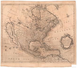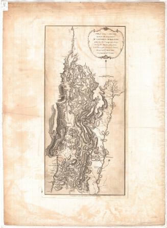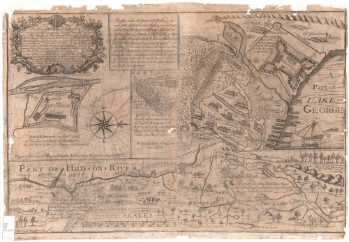
To His Excellency William Shirley, Esqr. Capt. General & Govr. in Chief in & over his Majesty's Province of ye Massachusetts Bay in New England Major General & Commander in Chief of all his Majesty's Land forces in North America. And to ye Legislators of ye Several Provinces Concerned in ye Expedition to Crown Point. This plan of Hudsons River from Albany to Fort Edward...
PrintmakerEngraved by
Thomas Johnston
American, 1708 - 1767
PrinterPrinted by
Thomas Johnston
American, 1708 - 1767
Date1756
MediumEngraving; black printer's ink on laid paper, backed with paper
DimensionsPrimary Dimensions (image height x width): 17 13/16 x 27 1/4in. (45.2 x 69.2cm)
Sheet (height x width): 18 7/8 x 27 9/16in. (47.9 x 70cm)
Mount (height x width): 19 3/8 x 27 9/16in. (49.2 x 70cm)
Sheet (height x width): 18 7/8 x 27 9/16in. (47.9 x 70cm)
Mount (height x width): 19 3/8 x 27 9/16in. (49.2 x 70cm)
ClassificationsGraphics
Credit LineConnecticut Museum of Culture and History collection
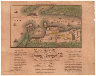
DescriptionTwo main maps, one of part of the Hudson River and the other part of Lake George. The Hudson River map is oriented east-west, with Albany City to the south and Lakes George and Champlain to the north. Various features of the river's flow are noted: notes about rocks, fast-moving or still water, and waterfalls appear on the map. The following forts are labeled and depicted with a symbol: Fort Edward, General Nicholsons' Fort, Saratoga, Fort William Henry, Ticonderoga, and Crown Point. A "carrying place" and the wagon road to Lake George are also marked.
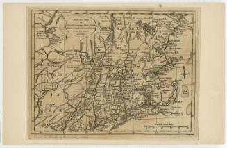
The map depicting part of Lake George focuses on Fort William Henry and the British camps set up around it, all flying the British flag. The inscription identifies the construction materials and the diagram labels the dungeon, storehouse, guard houses, barracks and magazines. Canoes are banked on the lake, and a British ship and two manned canoes are in it. To the left, there is an inset box with notes explaining three of the four numbers found on the map: 1 identifies the spot where Colonel Ephraim Williams was killed, 2 marks the place where Colonel Titcomb was killed, and 3 identifies the army's camps, with the commanding generals' and colonels' names next to each one. Below the inset, also to the left of the map, there is a note explaining that the number 4 was the hill on which battle was waged.
Right below the cartouche, there is an inset map of Fort Edward, along the Hudson River. The inscription identifies the construction material, and the diagram labels the hospital, storehouse, magazine and barracks.
The title is contained within a decorative cartouche, featuring a leafy design with scrolls and small flowers. At the top, there is a banner with the Latin phrase "pro rege et republica," which means, "for king and state."
Object number2012.312.78
MarkingsRecto, bottom left corner, printed in black ink on sticker: "MAPS / BOX / 192"InscribedRecto, top left, printed in black ink: "To His / Excellency William Shirley Esqr. Capt. / General & Govr. in Chief in & over his Majesty's Province of ye Massachusetts / Bay in New England Major General & Commander in Chief of all / his Majesty's Land forces in North America. / AND to ye Legislators of ye Several Provinces Concerned / in ye Expedition to CROWN-POINT. / This plan / OF Hudsons Riv. / from Albany to FORT / EDWARD, (& ye Road from thence to Lake George as Survey'd) Lake George, the / Narrows, Crown Point, part of Lake Champlain with its South Bay, / and Wood Creek according to ye best Accounts from ye French Genls. Plans, / & other observations (by Scale No. 1) & an Exact Plan of Fort Edward / & William Henry (by Scale No 2) & ye West end of Lake Geo; & of ye / Land defended on ye 8th of Sept. last & our Army's Intrenchment afterward / by Scale 3) & Sundry Particulars respecting ye late Engagement with ye dis- / tance & bearing of Crown point & wood Creek from No. 4 by / your most devoted Humble Serv: / Timo. Clement / Survr."Top left, below cartouche, printed in black ink: "Haverl. Feb. 10 1756"
Center left, printed in black ink: "Engrav'd & Printed by Thomas Johnston Boston New-England. April 1756"
Top, printed in black ink: "1 The place where the Brave Coll. Williams was / ambush'd & Killed, his Men Fighting on a Retreat / to the Main Body of our Army. Also where / Gapt. McGennes of York & Capt. Fulson of New / Hampshire Bravely Attackd he Enemy Killing many / the Rest Fled leaving their packs & Provisions- and / 2 also shews ye Place where the Valiant Col. Titcomb was Killed / it being the westerly Corner of the Land defended in ye general / Engagement which is Circumscribed with a double line westerly / & Southerly 3 within the [symbol]: double line is ye Form / 3 of our Armys Entrenchment which shews the Gen. / and Each Col; Apartment."
Center, printed in black ink: "4 A Hill from which the / Enemy did us much harm, and / during the Engagement, the / Enemy had great advantage the[illegible] / laying behind Trees we [illegible] / within Gun Shot of our front. / W. the place where the Wagoners / were Kill'd."NotesCartographic Note: Scale: 1 1/2 inches equals about 5 miles; 2 1/2 inches equals about 10 rods; 2 inches equals about 30 rods
Collections
- Maps and Charts: Finding Your Place in Connecticut History
On View
Not on view