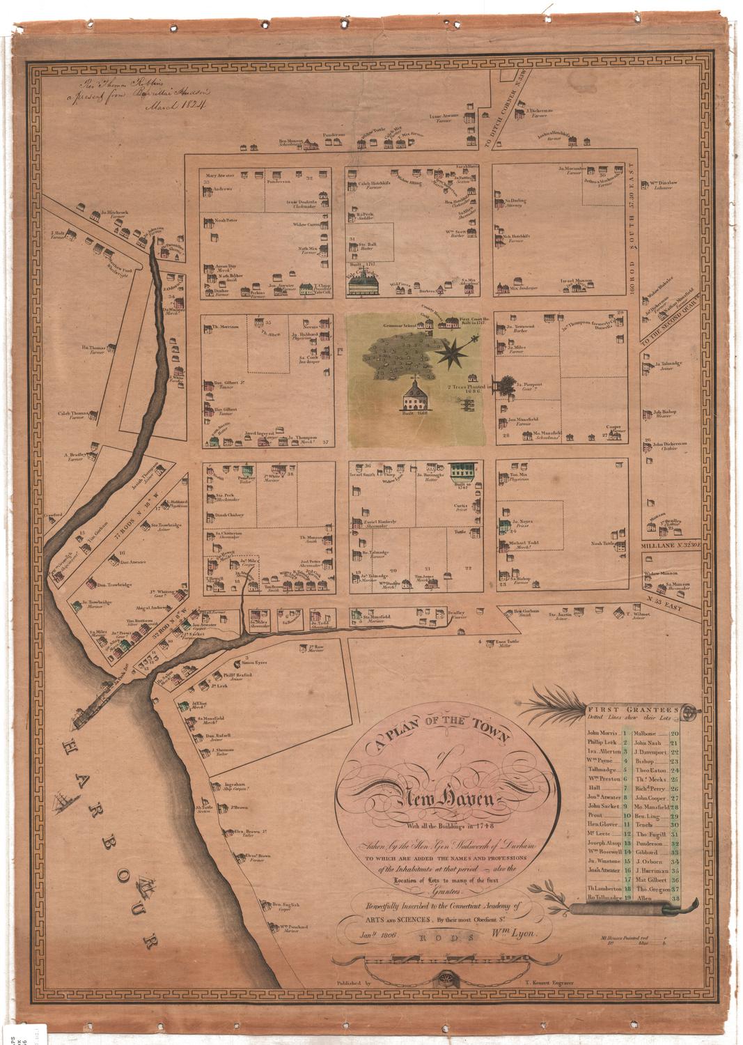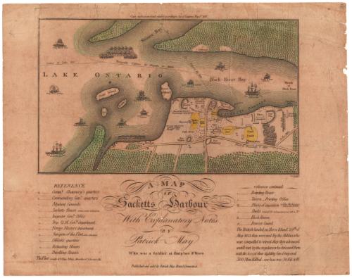
A Map of Sacketts Harbour
PublisherPublished by
Patrick May
American, died after 1815
Date1815
MediumEngraving; black printer's ink and watercolor on laid paper, lined with paper
DimensionsPrimary Dimensions (image height x width): 7 1/8 x 12in. (18.1 x 30.5cm)
Sheet (height x width): 12 1/2 x 15 7/8in. (31.8 x 40.3cm)
Mount (height x width): 12 1/2 x 15 7/8in. (31.8 x 40.3cm)
Sheet (height x width): 12 1/2 x 15 7/8in. (31.8 x 40.3cm)
Mount (height x width): 12 1/2 x 15 7/8in. (31.8 x 40.3cm)
ClassificationsGraphics
Credit LineConnecticut Museum of Culture and History collection
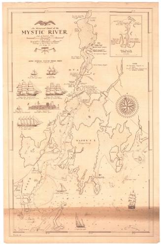
DescriptionMap of Sacketts Harbour (now Sackets Harbor) in Jefferson County, New York, extending from Simcoe Bay to the north, the mouth of the Black River to the east, the road to Brownville to the south, and a navigable course to Lake Erie to the west. Made during the War of 1812, the map shows the Battle of Sackets Harbor, which took place on May 29, 1813. The military and naval presence is well documented: on land, there are military cantonments, or barracks; forts; and ordnance, timber and navy yards; while in Lake Ontario, military ships and gun boats patrol the waters. Named ships include the Oneida (brig), the Mohawk (ship), the Jefferson (brig), the Growler (schooner), the Zilph (brig), the Spitfire (schooner), the Superior (ship), the Madison (ship), Pike (ship), Jones (brig), and the Lady of the Lake (schooner). A marine hospital, the public square, various stores, the brewery, the burying ground, and other notable places are labeled. Small symbols mark various dwelling places, including boarding houses; eating houses; taverns; printing offices; places of execution; sheds; block houses; and the location of the provost guard.Two inscriptions mark the fall of General Gray and the place where the dead enemy forces were buried.
Object number2012.312.74
MarkingsVerso, center, stamped in blue ink: "CtHi"InscribedRecto, top, printed in black ink: "Copy right secured and entered according to Act of Congress. May 1st. 1815"Right, below map image, printed in black ink: "LG Scultp."
Center, printed in black ink: "A MAP / OF / Sacketts Harbour / With Explanatory Notes / BY / Patrick May / Who was a Soldier at that place 2 Years"
Left, printed in black ink: "REFERENCE / [symbol] Comme Chauncey's quarters / [symbol] Commanding Genls. quarters / [symbol] Adjutant Generals / [symbols] Sacketts House prime owner of the place / [symbol] Inspector Gensl Office / [symbol] Dep. Q.M. Genls department / [symbol] Forage Masters department / [symbol] Surgeon of the Fleet a fine situation / [symbol] Officers quarters / [symbol] Victualing Houses / [symbol] Dwelling houses"
Right, printed in black ink: "reference continued / [symbol] Boarding House / [symbol] Tavern [symbol] Printing Office / [symbol] Places of execution NB Four Men have been / hung and 14 Shot / [symbol]Sheds occupied for various purposes 215 in No. / B Block Houses / P Provost Guard"
Bottom left, printed in black ink: "The Fleet consists of 4 Ships 4 Brigs A number of Schooners &c"
Bottom right, printed in black ink: "The British landed on Horse Island 29th of / May 1813, they were met by the Militia, who / were compelled to retreat; they then advanced / untill met by the regulars, who defeated them / with the loss of their fighting Gen. Gray and / 300 Men Killed. our loss was 50 Kil. & W."
Bottom center, printed in black ink: "Published and sold by Patrick May. Bristol Connecticut."
Verso, bottom left, handwritten in pencil: "MAP BOX / 46"
Bottom right, handwritten in pencil: "Map / Box 46"NotesCartographic Note: No Scale
Collections
- Maps and Charts: Finding Your Place in Connecticut History
On View
Not on view