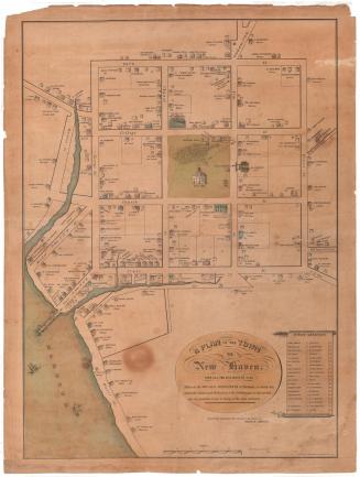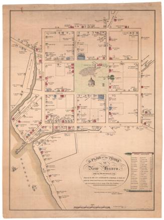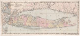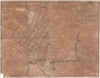
Plan of the Town of New Haven With all the Buildings in 1748
PrintmakerEngraved by
Thomas Kensett
American, 1786 - 1829
After a work byAfter a work by
James Wadsworth
American, 1730 - 1817
MakerDedicated by
William Lyon
American, 1748 - 1830
Date1806
MediumEngraving; black printer's ink and watercolor on paper, lined with linen
DimensionsPrimary Dimensions (image height x width): 26 3/4 x 19 1/2in. (67.9 x 49.5cm)
Sheet (height x width): 28 5/8 x 20 3/8in. (72.7 x 51.8cm)
Mount (height x width): 28 5/8 x 20 3/8in. (72.7 x 51.8cm)
Sheet (height x width): 28 5/8 x 20 3/8in. (72.7 x 51.8cm)
Mount (height x width): 28 5/8 x 20 3/8in. (72.7 x 51.8cm)
ClassificationsGraphics
Credit LineConnecticut Museum of Culture and History collection
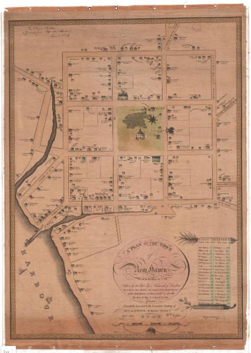
DescriptionMap of the city of New Haven, extending from the road to Ditch Corner to the north, Mill Lane to the east, the harbor to the south and west. With the exception of Mill Lane, none of the streets are named. Houses of varying sizes are depicted on the map, along with the name and profession of the owner or occupant. Only those houses given the code "r" or "b" (for red and blue, respectively) have been colored. In the center is the town green, with a grammar school, county house, court house, and a building that is labeled as the "goal," although this may be a misspelling of "gaol." There is a cemetery depicted in the green, a church that was built in 1668, an unlabeled building, and three canons. Also located in the green on the map is the eight-point compass and north arrow, oriented toward the top right corner of the map. Across from the green is Yale College at the top and "2 Trees Planted in 1686" at the right. In the harbor, several ships are sailing and are docked. The borders of the map are decorative, with a geometric pattern, and the list of First Grantees on the right side is in the shape of a scroll, at the top of which is a leafy branch that appears similar to a palm frond, and at the bottom of which is what appears to be an olive branch.
Object number2012.312.1
MarkingsRecto, bottom left, printed in black ink on sticker: "MAPS / Box / 160"InscribedRecto, top left, handwritten in black ink: Rev. Thomas Robbins / a present from Barzillai Hudson / March 1824"Center, printed in black ink: "A PLAN OF THE TOWN / of / New Haven / With all the Buildings in 1748 / taken by the Hon. Gen. Wadsworth of Durham / TO WHICH ARE ADDED THE NAMES AND PROFESSIONS / of the Inhabitants at that period also the / Locatino of Lots to many of the first / Grantees"
Bottom center, printed in black ink: "Respectfully Inscribed to the Connecticut Academy of / ARTS and SCIENCES, By their most Obedient St. / Jany. 1806 Wm Lyon."
Bottom center, printed in black ink: "Published by T. Kensett Engraver"
Right, printed in black ink: "FIRST GRANTEES / Dotted Lines shew their Lots / John Morris __ 1 / Phillip Leek __ 2 / Isa. Allerton 3 / Wm. Payne __ 4 / Tallmadge __ 5 / Wm. Preston 6 / Hall _____ 7 / Jonn. Atwater 8 / John Sacket _ 9 / Prout ____ 10 / Hen. Glover __ 11 / Mr. Leete ___ 12 / Joseph Alsop 13 / Wm. Rosewell 14 / Jn. Windstone 15 / Josh Atwater 16 / ______ 17 / Th Lamberton 18 / Ro Tallmadge 19 / Malbone ___ 20 / John Nash __ 21 / J. Davenport _ 22 / Bishop ___ 23 / Theo Eaton _ 24 / Ths. Meeks _ 25 / Richd. Perry _ 26 / John Cooper _ 27 / Mo. Mansfield 28 / Ben. Ling __ 29 / Tenchs __ 30 / Tho Fugill 31 / Punderson _ 32 / Gibbard __ 33 / J. Osborn 34 / J. Harriman 35 / Mat Gilbert 36 / Tho. Gregson 37 / Allen ___ 38"
Right, printed in black ink: "NB Houses painted red --- r / Do. blue -- b"
NotesCartographical Scale: About 3/4 of an inch equals 10 rods
Classification Note: In terms of this project, "historical maps" refer to those made at a later date than the time period depicted.
Collections
- Maps and Charts: Finding Your Place in Connecticut History
On View
Not on view