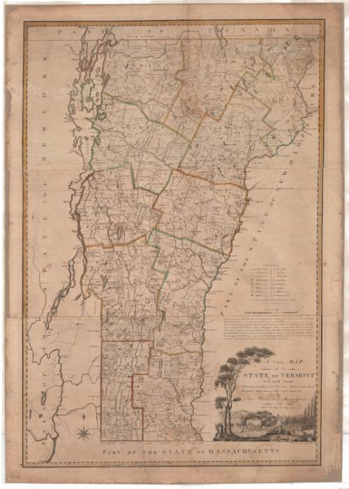
A Correct Map of the State of Vermont From actual Survey
MakerCompiled by
James Whitelaw
American, 1748 - 1829
PrinterEngraved by
Amos Doolittle
American, 1754 - 1832
PrinterPrinted by
Amos Doolittle
American, 1754 - 1832
Date1796
MediumEngraving; printer's ink and watercolor on paper
DimensionsPrimary Dimensions (image height x width): 45 1/4 x 30 1/2in. (114.9 x 77.5cm)
Sheet (height x width): 48 3/8 x 34 1/4in. (122.9 x 87cm)
Sheet (height x width): 48 3/8 x 34 1/4in. (122.9 x 87cm)
ClassificationsGraphics
Credit LineConnecticut Museum of Culture and History collection
DescriptionMap of Vermont, bordered on the north by Canada, the east by New Hampshire, the south by Massachusetts and the west by New York. Lines of latitude and longitude, the latter in degrees east from Washington, are marked in the border. The counties are outlined in double solid lines that have been hand colored in red, yellow, or green. Townships are outlined in single solid lines and include their dates of charter. Contested lines are marked as broken solid lines. On the right side is a key to the symbols found on the map: public roads, meeting houses, forts, falls, ferries, bridges, grist mills, saw mills, fulling mills, iron works, mountains, swamps, dwelling houses and grammar schools. An eight-point compass rose appears in the lower left.
The cartouche, in the lower right corner, is unframed and features a pastoral scene. Two trees on the left arch over the title text. Below the text is the depiction of farming life: a man and a woman walk behind a horse-drawn hay wagon with two people riding on the hay. In the foreground, two sheep sit in a small clearing surrounded by tree stumps, and to the right, two cows stand in a small running brook. A farmhouse and silo are behind a small orchard, and two fields with wheat sheaves are visible in the background.
The cartouche, in the lower right corner, is unframed and features a pastoral scene. Two trees on the left arch over the title text. Below the text is the depiction of farming life: a man and a woman walk behind a horse-drawn hay wagon with two people riding on the hay. In the foreground, two sheep sit in a small clearing surrounded by tree stumps, and to the right, two cows stand in a small running brook. A farmhouse and silo are behind a small orchard, and two fields with wheat sheaves are visible in the background.
Object number2012.312.153
InscribedRecto, right, printed in black ink: Key to the characters found on the mapRight, printed in black ink: "Scale of Miles"
Right, printed in black ink: "Note. The out lines of the townships of Orwell, Cornwall, Salisbury, Goshen, Hancock, Rochester, Bethel, / Royalton, Sharon and Norwich, & all north of them, are laid down from correct Surveys made under the / direction of the Surveyor General, between the years 1783 and 1790; and the lines of the towns south of the afore- / mentioned, together with the Roads, Streams, Meetinghouses, Mills &c. throughout the whole State, are laid down from / Plans forwarded by the Select men & Proprietors Clerks of the different townships, in pursuance of an act of the / General Assembly intitled an act for the purpose of collecting the necessary Surveys for compleating a Map of / the State, passed Octr. 31th 1793. -- Several towns neglected making returnes, and others were not very / particular, which is the cause that the roads are broken off in some places."
Bottom right, printed in black ink: "A Correct MAP / of the / STATE OF VERMONT / From actual Survey; / Exhibiting the County and Town lines, Rivers, Lakes, Ponds, / Mountains, Meetinghouses, Mills, Public Roads &c. / By / James Whitelaw Esqr. Surveyor General. / 1796 / With the Privilege of Copy Right."
Bottom right, below the cartouche, printed in black ink: "Engraved by Amos Doolittle New haven 1796"NotesCartographic Note: 5 1/4 inches equals 20 miles
Collections
- Maps and Charts: Finding Your Place in Connecticut History
On View
Not on view
Joel Knott Allen
1792
Joel Knott Allen
1791 or 1792