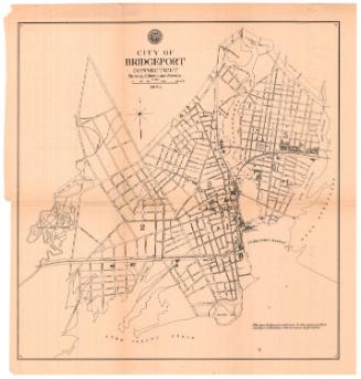
A map of Bridgeport Accurately Surveyed & Delineated
SurveyorSurveyed by
H. L. Barnum
American, active 1824 - 1836
DraftsmanDrawn by
H. L. Barnum
American, active 1824 - 1836
PrintmakerEngraved by
N. & S. S. Jocelyn
American, founded 1818
Date1824
MediumEngraving; black printer's ink and watercolor on laid paper, lined with linen
DimensionsPrimary Dimensions (image height x width): 17 3/16 x 21 3/16in. (43.7 x 53.8cm)
Sheet (height x width): 19 1/4 x 22 1/8in. (48.9 x 56.2cm)
Mount (height x width): 19 1/4 x 22 1/8in. (48.9 x 56.2cm)
Sheet (height x width): 19 1/4 x 22 1/8in. (48.9 x 56.2cm)
Mount (height x width): 19 1/4 x 22 1/8in. (48.9 x 56.2cm)
ClassificationsGraphics
Credit LineConnecticut Museum of Culture and History collection
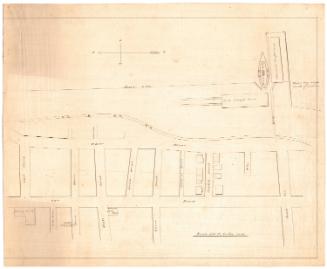
DescriptionStreet map of Bridgeport, Connecticut, extending from the turnpike to New Town and Litchfield to the north, Yellow-Mill Creek to the east, Captain Allen's residence to the south, and Stratfield Street to the west. The borough line is inscribed around the village in a broken solid and dotted line. The Paquanook (Poquonock) River and the Bridgeport harbor run through the center of the map, with the bridge spanning across the river from Beaver Street to an unnamed street, and sailboats and General LaFayette's steamship in the water. Residences and their owners, as well as churches, are depicted and labeled. Golden Hill is depicted in relief with hachure marks. In the top left, there is a list of references that provides the alphabetical abbreviations for the apothecary, baker, bookseller, cabinet maker, carriage maker, dry goods store, grocery store, hatter, lumber yard, printing office, plater, saddlery, tailor, toll house and watch maker. It also explains that the figures found on the map refer to fathoms at high water. An eight-point compass rose and north arrow appears on the left side of the map.
Object number2012.312.41
MarkingsRecto, top left, printed in black ink on sticker: "MAPS / Box / 263"Verso, top, three red stickers
Center bottom, handwritten in pencil on sticker: "1060"InscribedRecto, top right, printed in black ink: "A / Map /of / BRIDGEPORT, / Accurately Surveyed & Delineated / BY / H.L. Barnum / 1824 / N. & S.S. Jocelyn Sc. NewHaven"
On the left side, on Liberty Street, there are several hand-drawn boxes in pencil and the lines of Fayette and Lambert Streets have been extended, also in pencil.
REFERENCE
A: Apothecary / B: Bookseller / Bk: Book Seller / C: Cabinet Maker / Cr: Carriage Maker / D: Dry Goods Store / G: Grocery Store / H: Hatter / L: Lumber Yard / P: Printing Office / Pt: Plater / S: Saddlery / T: Tailor / Tl: Toll House / W: Watch Maker
Names of property owners that appear on the map include the following:
On Main Street (From North to South):
Capt. D. Sterling, L. Thompson and J. Pool, L. Hawley, N. Wade, S. Hawley, S. Porter, R. Gregory, D. Sterling, N. I. Skinner, H. Coty, P. Sterges, L. Lyon, S. Northrop, C. L. Nichols, W. Deforest, R. Tweedy, S. Tweedy, T. Gouge, J. Clark, T. Hubbell, S. Hull, N. Coleman and E. Gregory, R. Atwell, Mrs. Hubbell, E. Middlebrooks, S. Burr, Mrs. Wolsey, I. Burroughs (?), Rev. H. Judah, Miss L. Shepherd and Dr. Hobman, M. Hinman, L. C. Segee, J. Sterling, D. B. Nicholas, N. Northrop, I. Sherman, G. Hawley, R. Hyde, J. B. Hall, A. Hawley, J. Norman, W. H. Peabody and J. Roberts, F. Allen
On Gold Street (From West to East):
Mrs. B. Edwards, U. Jennings
On Golden-Hill Street (From East to West):
S. Sterling, Rev. E. Waterman, J. French
On Beaver Street (From East to West):
S. Boroughs, E. Hubbell Esq., Dr. N. Tisdale, David Sterling Jr., G. Kippen, D. Hubbell (across from the Methodist Meeting House), S. May, I. Peck
On Wall Street:
R. Linus
On Water Street (From North to South):
J. Cannon, S. Hubbell, J. Hubbell (next to Pt.), F. Knapp (next to G), Fairchild (between G and D, S), S. Nicholas (between P and G), D. Fayrweather (next to D), Beach and Peck, C. B. Hubbell,Hubbell and Thompson (next to the Market), S. Boroughs, Lyon & Co., W. Deforest, I. Burroughs, J. Prindle, S. Jones, A & W. Hawley, D. Youngs, M. Platt, M. Hawley and R. Nichols, Mrs. Hawley
On Broad Street (From North to South):
U. Umphries, E. Spinning (near to the Tannery), J. Backus Esq. (across from the Congregational M. H.), A. Curtis and C. O. Neal (across from the Episcopal Church), D. Oviatt, S. B. Furgerson, Capt. J. Brooks Jr., J. Standish, Captain J. Allen
On John Street (From West to East):
J. B. Baldwin, D. Lord, J. T. Thompson
On Bank Street:
G. Hayt (next to the Bank)
On State Street (From West to East):
T. C. Wordin, Mrs. Fayrweather, S. Hodge, L. Lockwood Esq., E. Bussey and C. M. Curtis (across from the Brick School), A. Sherman, J. Bouton, D. O. Wheeler, D. Fayrweather, D. Minor, A. Olmsted, W. H. Peet, S. Hawley (across from the Post Office), W. Peet. Esq., B. Wheeler (across from B)
On Allens Lane:
Capt. I. W. Allen
On Fayette Street (From North to South):
C. Tomlinson, J. Thorp
Across the bridge, between the River and the Creek:
On the road that extends from the Bridge to the road down to Stratford (From West to East):
B. Brooks Esq., E. Whiting, J. Brooks, Gen. E. Foot, C. Nichols, A. Benjamin, A. Beard, J. Cook (off the map)
On the rest of the roads:
B. Benjamin, O. Sherman, Hon. P. Edwards, J. Curtis, E. BoothNotesCartographic Note: Scale: 1 inch equals about 18 miles
Collections
- Maps and Charts: Finding Your Place in Connecticut History
On View
Not on view