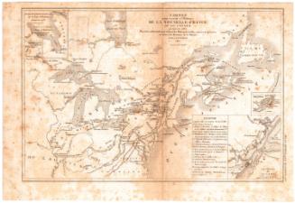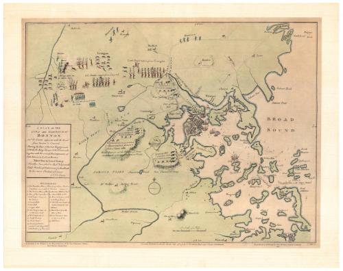
A Plan of the Town and Harbour of Boston
PrinterPrinted by
Meriden Gravure Company
American, 1888 - 1977
Date1963
MediumCollotype; black printer's ink and watercolor on paper
DimensionsPrimary Dimensions (image height x width): 14 3/8 x 18 7/8in. (36.5 x 47.9cm)
Sheet (height x width): 17 1/4 x 21 3/4in. (43.8 x 55.2cm)
Sheet (height x width): 17 1/4 x 21 3/4in. (43.8 x 55.2cm)
ClassificationsGraphics
Credit LineConnecticut Museum of Culture and History collection
DescriptionReproduction of a map of Boston, depicting the locations of the British and American troops in battles at Lexington and Concord and Bunker Hill, the army encampments, and the positions of ships in the harbor. The routes of the Minutemen, shown in blue coats and carrying rifles, are delineated at the top of the map. Below the title on the left side, there is a list of references that correspond to numbers found on the map, most of them clustered in and around the harbor area, that describe the ships, forts, batteries and events of the battles.
Object number1964.66.0
MarkingsVerso, center, stamped in blue ink: "CtHi"InscribedRecto, left side, printed in black ink: "A PLAN OF THE / TOWN and HARBOUR of / BOSTON. / and the Country adjacent with the Road / from Boston to Concord / Shewing the Place of the late Engagement between the King's Troops & the Provincials, / together with the several Encampments of / both Armies in & about Boston. / Taken from an Actual Survey / Humbly Inscribed to Richd. Whitworth / Esq. Member of Parliament for Stafford. / By his most Obedient Servant / J. De Costa"Bottom right, printed in black ink: "A facsimile of the Original in the Map Collection of the Yale University Library, / New Haven, Connecticut"
Bottom center, printed in black ink: "London Publish'd as the Act directs July 29th 1775 by J. De Costa Red Cross Street Southwark."
Bottom right, printed in black ink: "Reproduced in Collotype by The Meriden Gravure Company / 1963"
Bottom right, printed in black ink: "C. Hall Sc."NotesCartographic Note: No scale
Subject Note: The engagement that we now refer to as the Battle of Bunker Hill is simply identified as "the battle of 17th June 1775."
Collections
- Maps and Charts: Finding Your Place in Connecticut History
On View
Not on view