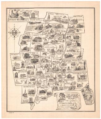
Map of Middlesex County
DraftsmanDrawn by
S. Jerome Hoxie
American, 1895 - 1981
PrinterPrinted by
Riverside Press
American, active 1934
PublisherPublished by
League of Women Voters of Connecticut
American, founded 1921
Date1934
MediumLithography; printer's ink on paper mounted on board
DimensionsPrimary Dimensions (image height x width): 18 x 15 3/8in. (45.7 x 39.1cm)
Sheet (height x width): 18 7/8 x 16in. (47.9 x 40.6cm)
Sheet (height x width): 18 7/8 x 16in. (47.9 x 40.6cm)
ClassificationsGraphics
Credit LineConnecticut Museum of Culture and History collection
DescriptionPictorial map of Middlesex County, Connecticut, with the names of its towns, their dates of settlement and incorporation, and small drawings of notable landmarks or events. The cartouche, which is in the form of a tavern sign, includes a banner with the words "League of Women Voters," the seal of Middlesex County, and three historic buildings, the Samuel Hubbard house, the Beldon Library, and a blacksmith shop. At the upper right is the seal of the Friendly Association of Upper Middletown.. Additional small images of the Seth Wetrmore house, the Leatherman, and the docks in Cromwell are in the lower margin.
Object number2005.191.0
InscribedBottom left, in cartouche, printed in black ink, "MAP OF / MIDDLESEX COUNTY"; lower left corner, printed in black ink: "Copyright 1934"NotesCartographic Note: No scaleCollections
- Maps and Charts: Finding Your Place in Connecticut History
On View
Not on view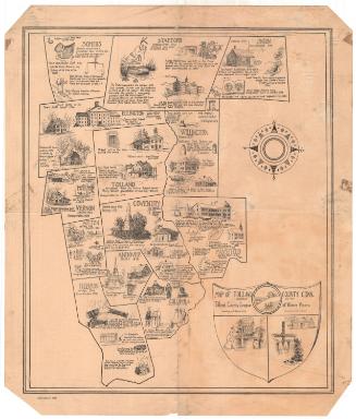
Connecticut Department of Agriculture