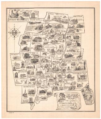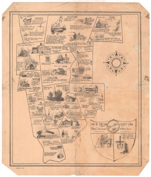
Map of Tolland County, Connecticut
DraftsmanDrawn by
S. Jerome Hoxie
American, 1895 - 1981
PrinterPrinted by
Riverside Press
American, active 1934
Date1934
MediumLithography; printer's ink on wove paper
DimensionsPrimary Dimensions (image height x width): 17 7/8 x 15 1/4in. (45.4 x 38.7cm)
Sheet (height x width): 20 x 17in. (50.8 x 43.2cm)
Sheet (height x width): 20 x 17in. (50.8 x 43.2cm)
ClassificationsGraphics
Credit LineGift of Lafayette Robinson
DescriptionPictorial map of Tolland County, Connecticut, with the names of its towns, their dates of settlement and incorporation, and small drawings of notable landmarks or events. The cartouche, which is in the form of a shield, includes the words "MAP OF TOLLAND COUNTY CONN. / Published for the / Tolland County League of Women Voters / Drawings by S. Jerome Hoxie - Printed by The Riverside Press, Mystic" and a seal with a farmer plowing. Separate vignettes show a cooper, the first silk mill in Mansfield, and a mill dam. A compass rose is at the upper right.
Object number1975.105.1
InscribedOn recto, lower right, in cartouche, printed in black ink, "MAP OF TOLLAND COUNTY CONN. / Published for the / Tolland County League of Women Voters"; lower left corner, printed in black ink, "Copyrighted 1934"NotesCartographic Note: No scaleCollections
- Maps and Charts: Finding Your Place in Connecticut History
On View
Not on view