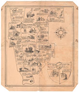
Historical Map of New London County, 1666-1933
DraftsmanDrawn by
S. Jerome Hoxie
American, 1895 - 1981
PublisherPublished by
League of Women Voters (New London County, Conn.)
American, founded after1920
Date1934
MediumLithography; black printer's ink on paper, mounted on mat board
DimensionsPrimary Dimensions (image height x width): 15 3/8 x 18 1/4in. (39.1 x 46.4cm)
Sheet (height x width): 16 3/8 x 19 5/8in. (41.6 x 49.8cm)
Mount (height x width): 16 3/8 x 19 5/8in. (41.6 x 49.8cm)
Sheet (height x width): 16 3/8 x 19 5/8in. (41.6 x 49.8cm)
Mount (height x width): 16 3/8 x 19 5/8in. (41.6 x 49.8cm)
ClassificationsGraphics
Credit LineConnecticut Museum of Culture and History collection
DescriptionPictorial map of New London County, Connecticut, with the names of its towns, their dates of settlement and incorporation, and small drawings of notable landmarks or events. The cartouche contains the city of New London's seal, depicting a three-masted ship, sails unfurled, with a banner above it with the Latin phrase, "Mare liberum," or "The freedom of the sea." To the left is an eight-point compass rose. The map is bordered on the right and left sides with a series of small drawings, presumably related to New London's history: a stalk of corn, a leaf, a bow, an arrowhead, a candle, a book, and more.
Object number2012.312.51
MarkingsRecto, bottom right corner, printed in black ink on sticker: "MAPS / BOX 369"InscribedRecto, top, printed in black ink: "Drawings BY S. Jerome Hoxie / 1933 / The New London County League of Women Voters / HISTORICAL MAP OF NEW LONDON COUNTY / 1666-1933"Bottom left corner, printed in black ink: "Copyright 1934"NotesCartographic Note: No scale
Collections
- Maps and Charts: Finding Your Place in Connecticut History
On View
Not on view