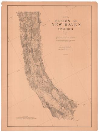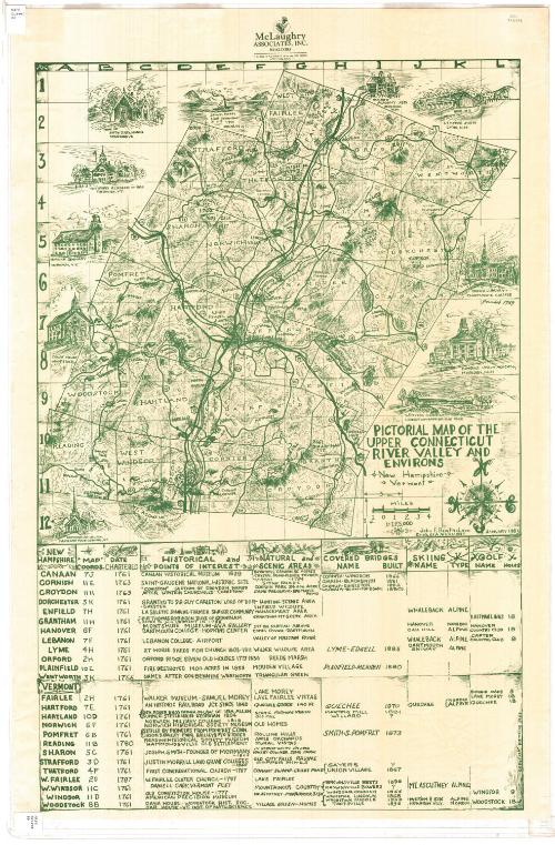
Pictorial Map of the Upper Connecticut River Valley and Environs
DraftsmanDrawn by
John F. Berthelsen
American, born about 1920
PublisherPublished by
McLaughry Associates
American, founded before 1970
Date1983
MediumLithography; green ink on wove paper
DimensionsPrimary Dimensions (image height x width): 33 1/8 x 21 5/8in. (84.1 x 54.9cm)
Sheet (height x width): 36 x 24in. (91.4 x 61cm)
Sheet (height x width): 36 x 24in. (91.4 x 61cm)
ClassificationsGraphics
Credit LineMuseum purchase
DescriptionPictorial map depicting the Connecticut River valley in Vermont and New Hampshire. On the map itself, there are small drawings that denote the locations of covered bridges, and symbols that represent ski areas and golf courses; while around the map are drawings that show churches, courthouses, private homes and academies. Elevation is conveyed through hachure marks. At the bottom is a list of towns on the map, their coordinates, date chartered, historical landmarks and points of interest, natural and scenic areas, covered bridges, and ski and golf areas.
Object number1983.191.1
MarkingsRecto, top right corner, stamped in blue ink: "CtHi"Top left corner, printed in black ink on sticker: "MAPS / Drawer / 86"
Verso, bottom left corner, printed in black ink: "Print / Drawer / 2A"InscribedRecto, top, printed in green ink: "McLaughry / ASSOCIATES, INC. / REALTORS / P.O. Box 111 32 Main St. Hanover, N.H. 03755 / 603 643-6400"
Top right, handwritten in pencil: "82804"
Right side, printed in green ink: "PICTORIAL MAP OF THE / UPPER CONNECTICUT / RIVER VALLEY AND / ENVIRONS / New Hampshire / Vermont"
Right side, printed in green ink: "John F. BERthELSEN / CHELSEA, VERMONT / JANUARY 1983"
Bottom right, printed in green ink: "copyright pending 1983"
Verso, top left corner, handwritten in pencil: "PRINT DRAWER 2A"NotesCartographic Note: Scale: 2 inches equals 4 miles; 1:125,000
Collections
- Maps and Charts: Finding Your Place in Connecticut History
On View
Not on view