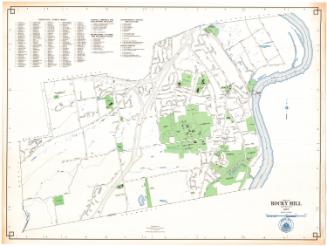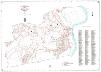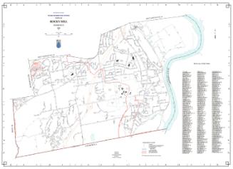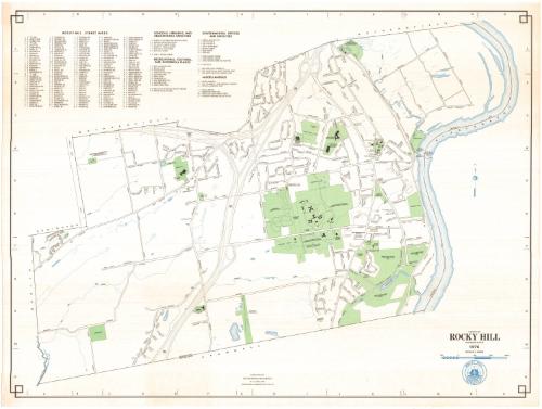
Town of Rocky Hill. Connecticut
MakerPrepared by the
Metropolitan District Commission
American, founded 1929
Date1976
MediumLithography; black and colored printer's inks on wove paper
DimensionsPrimary Dimensions (image height x width): 23 3/4 x 31 3/4in. (60.3 x 80.6cm)
Sheet (height x width): 24 3/4 x 32 3/4in. (62.9 x 83.2cm)
Sheet (height x width): 24 3/4 x 32 3/4in. (62.9 x 83.2cm)
ClassificationsGraphics
Credit LineConnecticut Museum of Culture and History collection
DescriptionMap of the town of Rocky Hill, Connecticut, with Wethersfield to the north, the Connecticut River and Glastonbury to the east, Cromwell to the south, and Berlin and Newington to the west. The Metropolitan District Commission Water Pollution Control Facility is in the northeast part of town. The Vexation Hill Water Storage Tank is in the northwest part of town. Other prominent features include Dinosaur State Park, Rose Hill Memorial Park, the Rocky Hill-Glastonbury Ferry, and the Veterans Hospital. Streets, railroads, streams, and ponds are shown. Interstate 91 and proposed Interstate 291 figure prominently, with a large highway interchange in the northern part of town. A scale of miles and the Rocky Hill seal are at the lower right. A street index and a key to schools, libraries, educational facilities, recreational facilities, cultural and historic sites, and govermment offices and facilities are upper left.
Object number1988.215.0
MarkingsOn verso, center, stamped in blue ink, "CtHi"InscribedOn recto, lower right, printed in black ink, "TOWN OF / ROCKY HILL / CONNECTICUT / 1976"On verso, lower right, in pcneil, "1988.215.0" "088213"NotesCartographic Note: One inch equals 1000 feet
Collections
- Maps and Charts: Finding Your Place in Connecticut History
On View
Not on view