Welcome to Hartford Illustrated Map
DesignerDesigned by
Carolyn S. West
American, born 1950
SponsorSponsored by
Business for Downtown Hartford
American, founded 1989
SponsorSponsored by
Connecticut Capitol Region Growth Council
American, founded 1992
SponsorSponsored by
City of Hartford
American
SponsorSponsored by
Hartford Downtown Council
American
SponsorSponsored by
Greater Hartford Chamber of Commerce
American
SponsorSponsored by
Greater Hartford Convention and Visitors Bureau
American
SponsorSponsored by
Greater Hartford Tourism District
American
SponsorSponsored by
MassMutual
American, founded 1851
SponsorSponsored by
State of Connecticut Office of Policy and Management
American, founded 1977
Date1998
MediumDigital inkjet print on paper sealed in plastic
DimensionsPrimary Dimensions (image height x width): 10 3/4 x 25 1/4in. (27.3 x 64.1cm)
Sheet (height x width): 11 5/16 x 26in. (28.7 x 66cm)
Mount (height x width): 11 3/4 x 26 1/4in. (29.8 x 66.7cm)
Sheet (height x width): 11 5/16 x 26in. (28.7 x 66cm)
Mount (height x width): 11 3/4 x 26 1/4in. (29.8 x 66.7cm)
ClassificationsGraphics
Credit LineGift of Carolyn S. West, CWest Designs
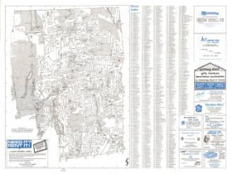
DescriptionPictorial map of Hartford, from Prospect Avenue on the west to East Hartford on the east and from Albany Avenue in the north to New Britain Avenue and Elliot Street in the south. Streets and highways are accurately depicted and exit numbers and exit ramps are shown. Three suggested walks are indicated by red, black, and blue lines. Bus routes are shown. Neighborhoods (West End, Asylum Hill, Parkville, Frog Hollow, Behind the Rocks, Barry Square, South Green, South End, Barry Square, Clay Arsenal, Sheldon-Charter Oak, South Meadows) are indicated by yellow signs. Pictures of many buildings, parks, and other attractions are used to show their locations. A key at the right lists Hotels, Shopping Areas, Parks and Recreation, Colleges and Universities, Hospitals, Transportation, Government Offices, Regional Services, Connecticut's Top Companies in Hartford, Religious Institutions, Good Works, Restaurants and Clubs. On the verso are lists of Metro Hartford Activities and Hartford Activities.
Object number2012.499.0
InscribedOn recto, upper center, printed in blue ink, "Welcome to Hartford"Upper right, printed in black ink, "Hartford Highlights"
Lower center, printed in black ink, "Connecticut State Capitol & Central Hartford"
Lower right, printed in blue ink, "This map is located on the Internet with links to many of the organizations listed"
On verso, lower right, in black ink, "2012.499.0"NotesCartographic Note: No scale
Constituent Note: The map was the gift of its designer.
Collections
- Maps and Charts: Finding Your Place in Connecticut History
On View
Not on view