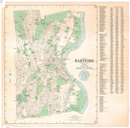
City of Hartford, Connecticut
MakerPrepared by the
Metropolitan District Commission
American, founded 1929
Date1979
MediumLithography; black, green and blue ink on wove paper
DimensionsPrimary Dimensions (image height x width): 16 5/8 x 13 1/16in. (42.2 x 33.2cm)
Sheet (height x width): 17 1/2 x 17 7/8in. (44.5 x 45.4cm)
Sheet (height x width): 17 1/2 x 17 7/8in. (44.5 x 45.4cm)
ClassificationsGraphics
Credit LineGift of Ursula Korzenik
DescriptionMap of the city of Hartford, Connecticut, from Bloomfield and Windsor to the north, the Connecticut River to the east, Newington and Wethersfield to the south, and West Hartford to the west. Streets are labeled and parks, schools, cemeteries, hospitals and state buildings are shown in green. The Connecticut River, Park River and various lakes and ponds are shown in blue. The city seal is in the cartouche. To the right of the map are a street index and lists of schools, libraries and educational facilities; recreational, cultural, and historical places; governmental offices and facilities; and miscellaneous sites.
Object number2004.142.1
MarkingsRecto, top and bottom left corners, printed in black ink on stickers: "MAPS / Box / 268"InscribedRecto, center right, printed in black ink: "CITY OF / HARTFORD / CONNECTICUT / 1979"Bottom, printed in black ink: "PREPARED BY / THE METROPOLITAN DISTRICT / P.O. BOX 800 / HARTFORD CONNECTICUT 06101"NotesCartographic Note: Scale: 1/2 inch equals 1000 feet
Subject Terms
- Hartford (Conn.)
- Connecticut River
- Park River (Hartford, Conn.)
- Rivers
- Schools
- Parks
- Keney Park (Hartford, Conn.)
- Goodwin Park (Hartford, Conn.)
- Elizabeth Park (Hartford, Conn.)
- Pope Park (Hartford, Conn.)
- Cemeteries
- Trinity College (Hartford, Conn.)
- Institute of Living (Hartford, Conn.)
- Hartford Hospital
- Hospitals
- Lithographs
- City and Town Maps
- Map Cataloging Project
- Hartford
Collections
- Maps and Charts: Finding Your Place in Connecticut History
On View
Not on view