The World
PublisherPublished by
Joseph Hutchins Colton
American, 1800 - 1893
Date1851
MediumLithography; black printer's ink and watercolor on wove paper, lined with linen, in paper covers
DimensionsPrimary Dimensions: 22 1/4 x 27 1/8in. (56.5 x 68.9cm)
Sheet: 23 1/4 x 27 7/8in. (59.1 x 70.8cm)
Mount: 23 1/4 x 27 7/8in. (59.1 x 70.8cm)
Sheet: 23 1/4 x 27 7/8in. (59.1 x 70.8cm)
Mount: 23 1/4 x 27 7/8in. (59.1 x 70.8cm)
ClassificationsGraphics
Credit LineConnecticut Museum of Culture and History collection
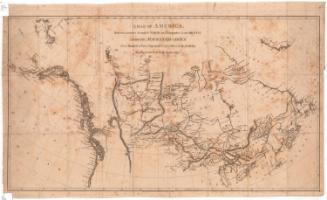
DescriptionPocket map of the world, with inset maps of the District of Columbia, Palestine, Monrovia, Liberia, Pitcairn Island, Juan Fernandez, Norfolk Island, and the Sandwich Islands. Countries are outlined in pink. Physical features are include elevation, conveyed with hachure marks; rivers; lakes; and islands. Exploration routes are shown in a variety of lines, and many of them are annotated with information about the explorer and his findings. Next to many of the islands in the South Pacific are notes about their land quality and/or whether they are inhabited. The borders are decorated with grapes and grape leaves.
Object number1957.82.0
InscribedFront cover, top right, handwritten in blue ink: "65013"Recto, top, printed in black ink: "THE WORLD"
Bottom, printed in black ink: "J.H. COLTON, No. 86. CEDAR STREET, NEW YORK. 1851"
Verso, top left side, handwritten in pencil: "Maps / 65013"NotesCartographic Note: No scale
Collections
- Maps and Charts: Finding Your Place in Connecticut History
On View
Not on view