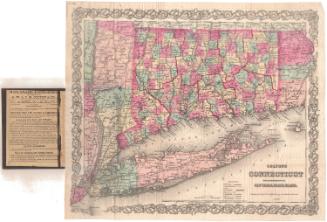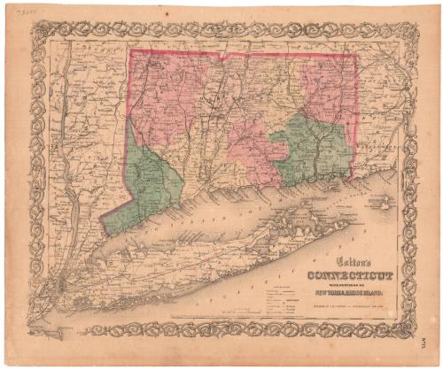
Colton's Connecticut with portions of New York and Rhode Island
PublisherPublished by
J. H. Colton & Co.
American, founded 1831
Date1855
MediumLithography; black printer's ink and watercolor on wove paper
DimensionsPrimary Dimensions (image height x width): 12 7/8 x 15 5/8in. (32.7 x 39.7cm)
Sheet (height x width): 14 1/2 x 17 1/2in. (36.8 x 44.5cm)
Sheet (height x width): 14 1/2 x 17 1/2in. (36.8 x 44.5cm)
ClassificationsGraphics
Credit LineMuseum purchase
DescriptionMap of Connecticut, the western portion of Rhode Island and the eastern portion of New York, with the border of Massachusetts to the north and Long Island and the Long Island Sound to the south. Connecticut is divided into counties, separated by broken solid and dotted lines and colored green, pink or yellow, and towns, separated by solid lines. Elevation is conveyed through hachure marks. Other natural features shown include rivers and islands. Common roads are marked with double parallel lines. Railroads are depicted, including the New York and Harlem; Long Island; New York and New Haven; Danbury and Norwalk; Housatonic; Naugatuck; New York and Boston Air Line; Hartford, Providence and Fishkill; New Haven and New London; Willimantic and Palmer, and Norwich and Worcester Railroads. On the back is a page of information about New York State.
Object number1969.67.2
InscribedRecto, top left, handwritten in pencil: "73088"Bottom right, printed in black ink: "Colton's / CONNECTICUT / WITH PORTIONS OF / NEW YORK & RHODE ISLAND / PUBLISHED BY J.H. COLTON No. 172 WILLIAM ST. NEW YORK."
Bottom center, printed in black ink: "Entered According to Act of Congress in the Year 1855, by J.H. Colton & Co. in the Clerks Office of the District Court of the United States for the Southern District of New York"
Bottom right, printed in black ink: "No. 15"
Verso, top right corner, handwritten in pencil: "8756"NotesCartographic Note: Scale: About 1 inch equals 10 miles
Collections
- Maps and Charts: Finding Your Place in Connecticut History
On View
Not on view