New Hampshire
PublisherPublished by
Joseph Hutchins Colton
American, 1800 - 1893
Date1855
MediumLIthography; black printer's ink and watercolor on wove paper, in cardboard covers
DimensionsPrimary Dimensions (image height x width): 15 3/4 x 12 1/4in. (40 x 31.1cm)
Sheet (height x width): 16 7/8 x 13 5/8in. (42.9 x 34.6cm)
Sheet (height x width): 16 7/8 x 13 5/8in. (42.9 x 34.6cm)
ClassificationsGraphics
Credit LineGift of Mrs. Francis T. Maxwell
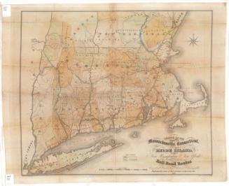
DescriptionPocket map of the state of New Hampshire, with part of Maine to the east, part of Massachusetts to the south, and part of Vermont to the west. The state is divided into counties, colored pink, blue, yellow, or peach, and is outlined in pink. The Portland Branch of the Grand Trunk; Vermont Central; Montreal; White Mountain; Concord and Claremont; Cheshire; Porsmouth and Concord; Boston and Maine; Nashua and Wilton; and Manchester and Lawrence Railroad lines are all shown. Local roads are depicted too, but are not labeled. Physical features include elevation, conveyed through hachure marks; rivers; and lakes.
Object number1928.10.2
MarkingsRecto, right side, blind stamped (two stamps): "IDE & DUTTON, / BOOKS, / MAPS & / GLOBES / 106 WASHINGTON ST. / BOSTON"InscribedFront cover, center, gold tooled: "MAP OF / NEW HAMPSHIRE / J.H. COLTON"Inside cover, top left, handwritten in red ink: "38674"
Top right, handwritten in pencil: "38"
Top, printed in black ink: "J. H. COLTON'S / Geographical Publishing Establishment, / NO. 86 CEDAR STREET, NEW YORK."
Advertisement for the different maps published by Colton's, including works in progress.
Recto, top left, printed in black ink: "NEW HAMPSHIRE"
Top left, printed in black ink: "PUBLISHED BY / J.H. COLTON & Co. / No. 172 WILLIAM St. / NEW YORK. / 1855"
Top right, printed in black ink: "Entered according to Act of Congress in the Year 1855 by / J.H. Colton in the District Court for the Southern Dist. of New York."
Verso, bottom left, handwritten in pencil: "MAPS / Shelf / 38674"NotesCartographic Note: 3/4 inch equals 10 miles
Collections
- Maps and Charts: Finding Your Place in Connecticut History
On View
Not on view