Hartford
After a work byAfter a work by
Defense Mapping Agency
American, founded 1972
After a work byAfter a work by
United States Army Topogaphic Command
American, 1968 - 1973
PrinterProbably printed by
Colorgraphics
American, founded 1976
Dateafter 1976
MediumOffset lithography; black and colored printer's inks on plastic
DimensionsPrimary Dimensions (image height x width): 17 5/8 x 26 1/2in. (44.8 x 67.3cm)
Sheet (height x width): 20 3/4 x 31in. (52.7 x 78.7cm)
Sheet (height x width): 20 3/4 x 31in. (52.7 x 78.7cm)
ClassificationsGraphics
Credit LineGift of Ursula Korzenik
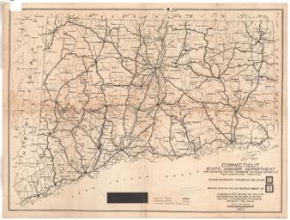
DescriptionRaised relief map of most of Connecticut, excluding the portion of the state east of Norwich, and part of New York State. Contour lines and relief are used to convey elevation. Cities' names appear in text that varies in size according to population. Yellow is presumably used to denote populated areas. Roads are shown, with different lines used to indicate whether they are primary or secondary roads and their surface quality.
Object number2004.142.5
MarkingsRecto, bottom left corner, printed in black ink on sticker: "COLORGRAPHICS 91 JOANNE DR., ROCH., NY 14616 / Phone (716) 225-2025"Verso, bottom right corner, stamped in black ink: "Connecticut Historical Society / Library"InscribedRecto, top left, printed in black ink: "EASTERN UNITED STATES 1:250,000"
Top center, printed in black ink, including logo: "DEFENSE MAPPING AGENCY / UNITED STATES OF AMERICA"
Top right, printed in black ink: "EDITION 3-DMATC"
Top right, printed in black ink: "NK 18-9 / SERIES V501P"
Bottom right, printed in black ink: "STOCK NO. V501PNK189"
Bottom left, printed in black ink: "V501P, EDITION 3-DMATC"
Bottom left, printed in black ink: "Prepared by the U.S. Army Topographic Command (KC), Washington, / D.C. Compiled in 1961 from United States quadrangles, 1:24,000, / 1:25,000, 1:31,680, and 1:50,000, 1932-58; NOS charts 1940-52. / Planimetry revised in part from aerial photographs taken 1957-58."
Bottom right, printed in black ink: "TRANSVERSE MERCATOR PROJECTION"
Bottom right, printed in black ink: "HARTFORD, CONN.; N.Y.; N.J.; MASS. / NK 18-9"
Right margin, printed in black ink, "ROAD DATA 1974"
Verso, bottom right, handwritten in pencil: "98456"
NotesCartographic Note: Scale: 1:250,000
Constituent Note: The United States Army Map Service was established during World War II to facilitate the production of military maps with minimal fieldwork. In 1968, the Army Map Service became the United States Army Topographic Command, and in 1972, it became part of the Defense Map Agency.
Collections
- Maps and Charts: Finding Your Place in Connecticut History
On View
Not on view

Connecticut State Highway Department
1923