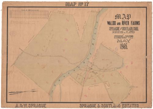
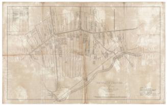
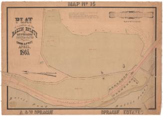
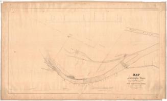
Map of the Waldo and River Farms in Sprague and Scotland, Connecticut
SurveyorSurveyed by
Cushing & Dewitt
American
DraftsmanDrawn by
William E. Cushing
American, 1845 - 1880
Date1865
MediumDrawing; black ink and watercolor on paper, lined with linen
DimensionsPrimary Dimensions (image height x width): 27 1/8 x 39in. (68.9 x 99.1cm)
Sheet (height x width): 30 x 41 3/4in. (76.2 x 106cm)
Mount (height x width): 30 x 41 3/4in. (76.2 x 106cm)
Sheet (height x width): 30 x 41 3/4in. (76.2 x 106cm)
Mount (height x width): 30 x 41 3/4in. (76.2 x 106cm)
ClassificationsGraphics
Credit LineConnecticut Museum of Culture and History collection
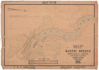
DescriptionMap of two farms along the Shetucket River in Sprague and Scotland, Connecticut. The map is oriented east-west on the paper with the river oriented vertically. The Waldo Farm, which is located north of the Shetucket River, on the right side of the map, and the River Farm, located south of the river, on the left. The dimensions of each side of the lots the farms are on are provided, with additional dimensions for the house and barn at Waldo Farm. Around River Farm, neighboring land owners include David Scott, Buell Ladd, Aaron Bailey, William Ladd and Cheeney Armstrong. Around Waldo Farm, neighboring land owners include Ebenezer Waldo, Elias Parkhurst, John Bingham, Nathan Fuller, Fenner Maine, Roger Waldo and George Waldo. Local roads; bridges over Merrick's Brook; and the Providence, Hartford, and Fishkill Railroad line are also depicted. At the top left is the scale chart.
Object number2012.312.236
MarkingsRecto, left side, blind stamped: "CUSHING & DEWITT / CIVIL AND / HYDRAULIC / ENGINEERS / AND / LAND SURVEYORS / 17 / SOUTH MAIN ST. PROVIDENCE RI"InscribedRecto, top center, handwritten in black ink: "MAP No. 17"Top right, handwritten in black ink: "MAP / OF THE / WALDO AND RIVER FARMS / IN / SPRAGUE AND SCOTLAND, CONN. / SURVEYED & PLATTED / BY / CUSHING & DeWITT / MAY, / 1865. / Wm. E. Cushing"
Top left, handwritten in black ink: "All distances in feet and decimals, U.S. Standard. / All Areas in Acres and decimals. / Magnetic courses taken with the Compass needle."
Bottom left, handwritten in black ink: "A. & W. SPRAGUE"
Bottom right, handwritten in black ink: "SPRAGUE & SCOTLAND ESTATES"NotesCartographic Note: Scale: 1 inch equals 200 feet
Collections
- Maps and Charts: Finding Your Place in Connecticut History
On View
Not on view
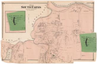

Sherman Wolcott Adams
1885