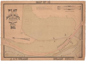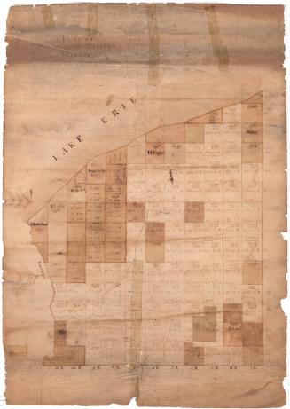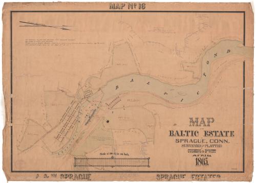
Map of the Baltic Estate in Sprague, Connecticut
SurveyorSurveyed by
Cushing & Dewitt
American
DraftsmanDrawn by
William E. Cushing
American, 1845 - 1880
Date1865
MediumDrawing; black and red ink and watercolor on wove paper, lined with linen
DimensionsPrimary Dimensions (image height x width): 27 1/16 x 39in. (68.7 x 99.1cm)
Sheet (height x width): 29 3/4 x 41 1/2in. (75.6 x 105.4cm)
Mount (height x width): 29 3/4 x 41 1/2in. (75.6 x 105.4cm)
Sheet (height x width): 29 3/4 x 41 1/2in. (75.6 x 105.4cm)
Mount (height x width): 29 3/4 x 41 1/2in. (75.6 x 105.4cm)
ClassificationsGraphics
Credit LineConnecticut Museum of Culture and History collection
DescriptionMap of Sprague, Connecticut, showing parcels of land belonging to William Sprague near the Shetucket River and Baltic Pond. Each parcel is labeled with its measurements in feet and area in acres, sometimes with notes about when it was purchased by the A. & W. Sprague Manufacturing Company. Additions to the map appear in blue pen and detail the sale of land from private owners to the Baltic Power Company in 1898. The cotton mill buildings are visible on the left side of the map along the Shetucket River. The names of some of the nearby property owners are also shown.
Object number2012.312.234
MarkingsRecto, bottom left, blind stamped: "CUSHING & DEWITT / CIVIL AND / HYDRAULIC / ENGINEERS / AND / LAND SURVEYORS / 17 / SOUTH MAIN St PROVIDENCE RI"InscribedRecto, top center, hand-drawn in black ink: "MAP No. 16"Top left, handwritten in black ink: "All distances in feet and decimals, U.S. standard measure. / All areas in acres and decimals. / Total area of Baltic Estate, 336 75/100 Acres: Add Area of "Currier Purchase," 56 21/100 A. = 392 96/100 Acres. / For further details, notes, etc. see Maps Nos 14 + 15."
Bottom right, hand-drawn in black ink: "MAP / OF THE / BALTIC ESTATE / IN / SPRAGUE, CONN. / SURVEYED AND PLATTED / BY CUSHING & DEWITT / APRIL, / 1865."
Bottom right corner, handwritten in black ink: "Wm. E. Cushing"
Bottom left, hand-drawn in black ink: "A. & W. SPRAGUE"
Bottom right, hand-drawn in black ink: "SPRAGUE ESTATES"
Names of property owners, above river and pond: A. R. Barbor, Nathan Bennett, A.J. Currier, Rinda Ladd, wife of George Williams, Lydia Ladd, Septa Ladd, Lawrence Brewster, Simeon Hazen, S.J.P. Ladd, George K. Nason [added later], Maria M. Wilcox [added later], Le Blanc [added later]
Names of property owners, below river and pond: Cornelius Donahue, Samuel Miller and Barnes, John Falvey, John Welon, John Curtin, John Kane, John Brooks, Levi P. and Eunice H. Rowland, John Grant, George K. Nason [added later], Maria M. Wilcox [added later]
NotesCartographic Note: Scale: 1 inch equals 300 feet
Collections
- Maps and Charts: Finding Your Place in Connecticut History
On View
Not on view