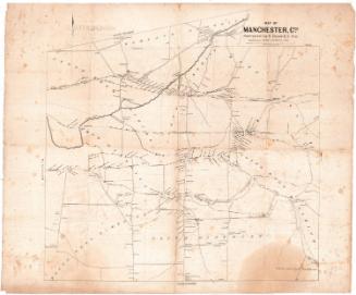
Plat of Baltic, Connecticut
SurveyorSurveyed by
Cushing & Dewitt
American
DraftsmanDrawn by
William E. Cushing
American, 1845 - 1880
Date1865
MediumDrawing; black and red ink and watercolor on wove paper, lined with linen
DimensionsPrimary Dimensions (image height x width): 29 1/8 x 41 1/2in. (74 x 105.4cm)
Sheet (height x width): 29 1/8 x 41 1/2in. (74 x 105.4cm)
Mount (height x width): 29 1/8 x 41 1/2in. (74 x 105.4cm)
Sheet (height x width): 29 1/8 x 41 1/2in. (74 x 105.4cm)
Mount (height x width): 29 1/8 x 41 1/2in. (74 x 105.4cm)
ClassificationsGraphics
Credit LineConnecticut Museum of Culture and History collection
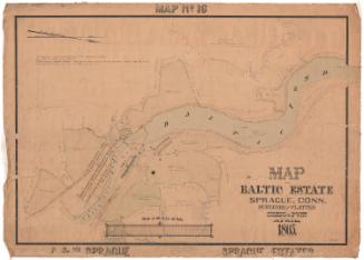
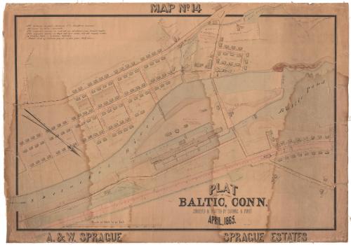
DescriptionMap of part of Baltic, Connecticut, where the Shetucket River and Baltic Pond connect. Oriented so that north points to the bottom right corner, the map shows the Stone Cotton Mill and its various buildings, mill housing, a saw mill, grist mill and woolen mill. Other buildings near Mill Pond include a store, a post office, a Baptist church, and Baltic House. In the bottom right section fo the map are a barn, farm house and an agent's house. The Hartford, Providence and Fishkill Railroad runs parallel to the Shetucket River, with the station on the right side of the map. The dimensions of land parcels and some buildings are provided, along with information about the owner and/or sale of the land to its then-current owner.
Object number2012.312.233
MarkingsRecto, bottom left corner, blind stamped: "CUSHING & DEWITT / CIVIL AND / HYDRAULIC / ENGINEERS / AND / LAND SURVEYORS / 17 / SOUTH MAIN St PROVIDENCE RI"Verso, bottom left corner, stamped in black ink: "Plaintiff [illegible] / C. R. Paul Hoffman / Stenographer."InscribedRecto, top, hand-drawn in black ink: "MAP No. 14"
Top left, handwritten in black ink: "All distances in feet + decimals, U.S. standard measure. / All areas in acres + decimals. / The magnetic courses in red ink are calculated from transit angles. / [dot within square] denotes well. [dot within circle] denotes hydrant. / Total area of enclosed parcels on this plat, 66 37/100 acres."
Bottom, hand-drawn in black ink: "PLAT / OF / BALTIC, CONN. / SURVEYED & PLATTED BY CUSHING & DEWITT / APRIL, 1865."
Bottom, handwritten in black ink: "Wm. E. Cushing"
Bottom left, hand-drawn in black ink: "A. & W. SPRAGUE"
Bottom right, hand-drawn in black ink: "SPRAGUE ESTATES"NotesCartographic Note: Scale: 1 inch equals 100 feet
Collections
- Maps and Charts: Finding Your Place in Connecticut History
On View
Not on view