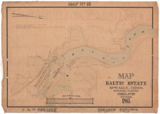
Plat of the portion of the Baltic Estate, East of the Railroad
SurveyorSurveyed by
Cushing & Dewitt
American
DraftsmanDrawn by
William E. Cushing
American, 1845 - 1880
Date1865
MediumDrawing; black and red ink and watercolor on wove paper, lined with linen
DimensionsPrimary Dimensions (image height x width): 27 1/8 x 39in. (68.9 x 99.1cm)
Sheet (height x width): 29 7/8 x 41 1/2in. (75.9 x 105.4cm)
Mount (height x width): 29 7/8 x 41 1/2in. (75.9 x 105.4cm)
Sheet (height x width): 29 7/8 x 41 1/2in. (75.9 x 105.4cm)
Mount (height x width): 29 7/8 x 41 1/2in. (75.9 x 105.4cm)
ClassificationsGraphics
Credit LineConnecticut Museum of Culture and History collection
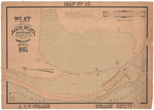
DescriptionMap of the part of the Sprague family estate east of Baltic Pond, in Sprague, Connecticut, where the Baltic Cotton Mill was established. The map shows the boundary lines of four parcels of land, plus part of two more. The barn, farm house and agent's house are depicted with perimeter measurements. Between the pond and the two largest parcels of land is the Providence, Hartford and Fishkill Railroad, with its station located near the intersection of the public highway on the right side of the map. The scale marker is decorative, with leafy embellishments.
Object number2012.312.235
MarkingsRecto, bottom left, blind stamped: "CUSHING & DEWITT / CIVIL AND / HYDRAULIC / ENGINEERS / AND / LAND SURVEYORS / 17 / SOUTH MAIN St PROVIDENCE RI"InscribedRecto, top center, hand-drawn in black ink: "MAP No. 15"Left, hand-drawn in black ink: "PLAT / of a portion of the / BALTIC ESTATE / EAST OF THE RAILROAD. / SURVEYED AND PLANNED / by / CUSHING & DEWITT, / APRIL, / 1865."
Left, handwritten in black ink: "Wm. E. Cushing"
Center, handwritten in black ink: "All distances in feet + decimals, U.S. standard measure. / All areas in acres + decimals. / Magnetic courses were taken with the compass needle. / Total area of land east of the railroad, 98 8/100 acres. / Total area of entire parcels on this plat, 102 31/100 acres."
Bottom left, hand-drawn in black ink: "A. & W. SPRAGUE"
Bottom right, hand-drawn in black ink: "SPRAGUE ESTATES"
Verso, bottom right corner, handwritten in orange pencil: "Baltic Estate / East of R.R. [illegible] / No 15"
NotesCartographic Note: Scale: 1 inch equals 100 feet
Collections
- Maps and Charts: Finding Your Place in Connecticut History
On View
Not on view