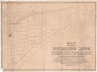
Building lots on Asylum Hill
PrinterPrinted by
E.B. & E.C. Kellogg
American, 1840 - 1867
Datebefore 1867
MediumLithography; black printer's ink on wove paper
DimensionsPrimary Dimensions (image height x width): 20 5/8 x 28 3/8in. (52.4 x 72.1cm)
Sheet (height x width): 21 5/8 x 29 1/4in. (54.9 x 74.3cm)
Sheet (height x width): 21 5/8 x 29 1/4in. (54.9 x 74.3cm)
ClassificationsGraphics
Credit LineConnecticut Museum of Culture and History collection
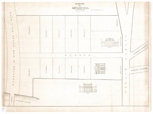
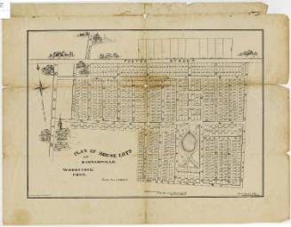
DescriptionMap of part of Asylum Hill in Hartford, Connecticut, depicting what was probably Hopkins Avenue and the lots and houses on it. It is bounded to the east by Asylum Street (now Asylum Avenue), beyond which are Garden and Spring Streets, to the southwest by the "Sickenam" River (the Park River), and to the west by the Hartford and New Haven Railroad. There are 11 unnamed plots of land with dimensions, and three that have sketches of houses on them: two that have owners (O.E. Williams and J. Catlin) and one that is labeled, "Fancy Residence."
Object number2012.312.171
MarkingsRecto, bottom left corner, printed in black ink on sticker: "Maps / Drawer / 119"InscribedRecto, top, printed in black ink: "BUILDING LOTS / ON / ASYLUM HILL. / Lith of E.B. & E.C. Kellogg / A few of these Lots are for sale"Verso, right side, handwritten in pencil: "O.E. Williams to / W. Wadsworth / Map"
Right side, handwritten in black ink: "with [illegible] of / O.E. Williams"NotesCartographic Note: No scale
Collections
- Maps and Charts: Finding Your Place in Connecticut History
On View
Not on view
D. W. Kellogg & Co.
1830-1840