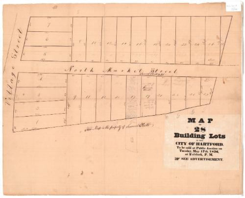
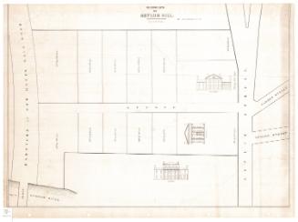
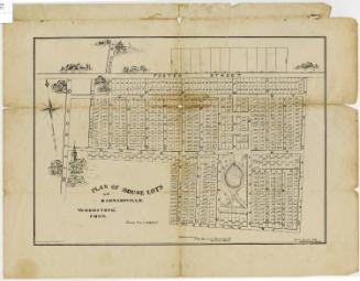
Map of 28 Building Lots in the City of Hartford
MakerMade by
Unknown
Date1836
MediumDrawing; ink on paper
DimensionsPrimary Dimensions (image height x width): 15 1/2 x 22in. (39.4 x 55.9cm)
Sheet (height x width): 19 1/8 x 23 5/8in. (48.6 x 60cm)
Sheet (height x width): 19 1/8 x 23 5/8in. (48.6 x 60cm)
ClassificationsGraphics
Credit LineConnecticut Museum of Culture and History collection
DescriptionMap of twenty-eight lots, with dimensions, in Hartford, Connecticut, on the north and south sides of North Market Street, with Village Street to the west.
Object number2012.312.18
MarkingsRecto, lower right, printed in black ink on paper adhered to map: "MAP / OF / 28 / Building Lots / IN THE / CITY OF HARTFORD. / To be sold at Public Auction on / Tuesday, May 17, 1836, / at 2 o'clock, P.M. / SEE ADVERTISEMENT."InscribedRecto, bottom center, handwritten in black ink: "This Map is the property of Samuel Olcott"Many of the lots are marked in pencil with names of the people who presumably purchased the lots: Samuel Olcott or S. Olcott, French, EB or E. Bolles (?) and Allen.NotesCartographic Note: No scale
During the 1830s, new houses were going up in the North End of Hartford. At this time, maps of property for sale were often provided to would-be purchasers by auctioneers. This unique manuscript map of twenty-eight lots between Market Street and Village Street belonged to Samuel Olcott, who purchased one of the lots. It may be difficult for modern viewers to figure out exactly where these lots were located. The layout of Market Street was altered several times between 1836 and the present, and Village Street was entirely eliminated in 1963, during urban renewal.
Collections
- Maps and Charts: Finding Your Place in Connecticut History
On View
Not on view

D. W. Kellogg & Co.
1830-1840

Sherman Wolcott Adams
1885