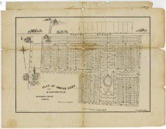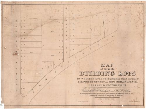
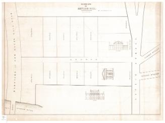
Map of valuable building lots on Webster Street (Washington Street continued) Ellsworth Street and New Britain Avenue, Hartford, Conn.
DraftsmanDrawn by
Jacob Weidenmann
American, 1829 - 1893
PrinterPrinted by
E.B. & E.C. Kellogg
American, 1840 - 1867
Dateafter 1860
MediumLithography; printer's ink on wove paper
DimensionsPrimary Dimensions (image height x width): 21 1/2 x 29 5/8in. (54.6 x 75.2cm)
Sheet (height x width): 22 3/4 x 30 3/8in. (57.8 x 77.2cm)
Sheet (height x width): 22 3/4 x 30 3/8in. (57.8 x 77.2cm)
ClassificationsGraphics
Credit LineConnecticut Museum of Culture and History collection
DescriptionPlat map of lots at intersection of Webster Street and New Britain Avenue. Webster Street is at the left and New Britain Avenue at the bottom of the map. Ellsworth Street runs parllel to Webster Street. Lots are numbered 1 to 27 and dimensions are inscribed along the sides of the lots. The sizes of the lots vary greatly. The name "John M. Read" is written in pencil at the right, and a rough rectangle, possibly a crude sketch plan for a building, is drawn in pencil on the adjoining lot.
Object number2005.198.0
InscribedOn recto, lower right, printed in black ink, "MAP / of valuable / BUILDING LOTS / ON WEBSTER STREET (Washington Street continued) / ELLSWORTH STREET AND NEW BRITAIN AVENUE, / HARTFORD, CONNECTICUT / Owned by E. I. Cleveland and Wm. S. Allen. / This Property embraces nearly seven acres, and commands one of the finest views of the / Connecticut River Valley of any locality in the State / SCALE 40 FEET TO 1 INCH."On verso, along right edge, in pencil, "Plan of Lots / Cleveland & Allen"NotesCartographic Note: No scale
Date Note: Jacob Weidenmann, who surveyed the lots shown in the map, came to the United States in 1856. The plot of land depicted is probably the same one that was offered for sale as a unit in April 1860. E.B. and E.C. Kellogg, who printed this map, were in busniss until 1866. It seems likely that map dates from between 1860 and 1867.
Collections
- Maps and Charts: Finding Your Place in Connecticut History
On View
Not on view
D. W. Kellogg & Co.
1830-1840