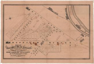
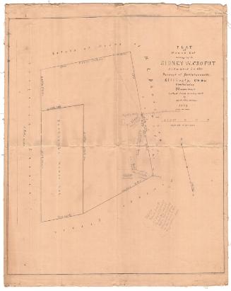
Map of Valuable Building Lots Situated on Main Street Continued
SurveyorSurveyed by
Unknown
DraftsmanDrawn by
Unknown
PrinterPrinted by
Unknown
Date1852
MediumLithography; black printer's ink on wove paper
DimensionsPrimary Dimensions (image height x width): 28 1/4 x 22 7/8in. (71.8 x 58.1cm)
Sheet (height x width): 39 3/8 x 25 3/4in. (100 x 65.4cm)
Sheet (height x width): 39 3/8 x 25 3/4in. (100 x 65.4cm)
ClassificationsGraphics
Credit LineGift of Leslie T. Goodrich
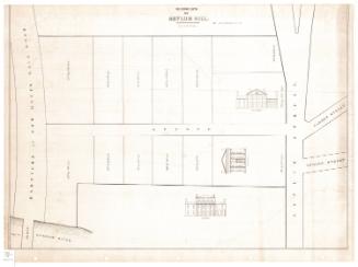
DescriptionMap of building lots in Hartford, Connecticut, along Front and Main Streets, with South Street running perpendicular. The lots are numbered from 1-56 and the lengths in feet are given. On lot 4 is "Never failing Water," and on lot 6 is a barn. The lots are bounded on one side by land belonging to the South Ecclesiastical Society and on the other by land belonging to Richard G. Drake.
Object number1946.18.0
InscribedRecto, top left corner, handwritten in brown ink: "55807"Top, printed in black ink: "MAP / OF / VALUABLE BUILDING LOTS / SITUATED ON / MAIN STREET CONTINUE, / One Mile South of the State House and comm[illegible]ing an unequalled view of the Valley of the Connecticut, / being decidedly the best unoccupied Cottage Scites [?] in the vicinity of the City of Hartford.-- / These Lots will be sold at AUCTION on the pr[illegible]ises on Saturday ["Saturday" in pencil] August 28th ["28th" in pencil] 1852 at 10 oclock, A.M."
Verso, bottom right corner, handwritten in pencil: "MAP BOX #76"
Bottom left corner, handwritten in pencil: "Col [?] Colt [?] / [illegible] / C. Barnard"NotesCartographic Note: No scale
Constituent Note: The map was probably printed by either E.B. & E.C. Kellogg or by Case & Green, the two major lithography firms active in Hartford in the early 1850s.
Collections
- Maps and Charts: Finding Your Place in Connecticut History
On View
Not on view
D. W. Kellogg & Co.
1830-1840