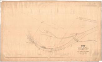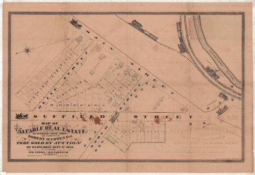
Map of Valuable Real Estate in Windsor Locks, Connecticut
SurveyorSurveyed by
Hiram G. Loomis
American, 1834 - 1911
PrinterPrinted by
Kellogg & Bulkeley
American, 1867 - 1990
Date1873
MediumLithography; black printer's ink on wove paper
DimensionsPrimary Dimensions (image height x width): 21 1/2 x 33 1/2in. (54.6 x 85.1cm)
Sheet (height x width): 24 1/8 x 35 1/4in. (61.3 x 89.5cm)
Sheet (height x width): 24 1/8 x 35 1/4in. (61.3 x 89.5cm)
ClassificationsGraphics
Credit LineConnecticut Museum of Culture and History collection
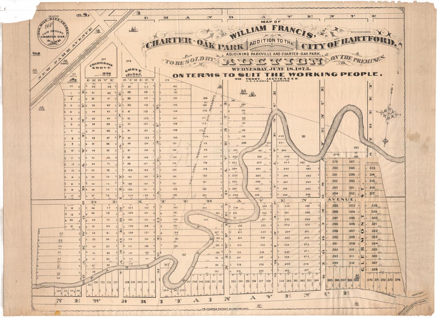
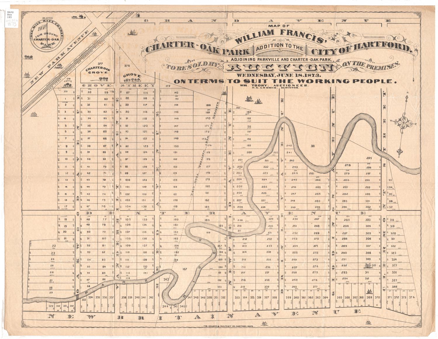
DescriptionMap of part of Windsor Locks, Connecticut, from Main Street to the north, the Connecticut River to the east, Suffield Street to the south, and Olive Street to the west. Numbered lots of land are depicted, with dimensions and, in some cases, shaded rectangles marking the locations of buildings. The Suffield Branch and New York, New Haven and Hartford Railroad lines are depicted running alongside the river, and are decorated with images of trains. Also running parallel to the river is the Enfield Falls Canal (not labeled), which is decorated with a vignette of the Seymour Paper Company. The roads depicted are accompanied by images of horse-drawn carriages.
Object number2012.312.123
MarkingsRecto, top and bottom left corners, printed in black ink on stickers: "MAPS / Drawer / 15"InscribedRecto, bottom left, printed in black ink: "MAP OF / VALUABLE REAL ESTATE / IN WINDSOR LOCKS, CONN. / THE PROPERTY OF / ROBERT McCOWEN, Esq. / TO BE SOLD BY AUCTION / ON WEDNESDAY, SEPT. 17 1873. / AT 11. O'CLOCK. / WM. TOOHY. AUCTIONEER. / H.G. LOOMIS, C.E. / SCALE 50 FEET TO AN INCH AUGUST, 1873."Bottom right corner, printed in black ink: "THE KELLOGG & BULKELEY CO. HARTFORD, CONN."
In the land lots, handwritten in pencil: Person's name and dollar amount
Verso, top left, handwritten in pencil and black ink: Various calculationsNotesCartographic Note: Scale: 1 inch equals 50 feet
Collections
- Maps and Charts: Finding Your Place in Connecticut History
On View
Not on view