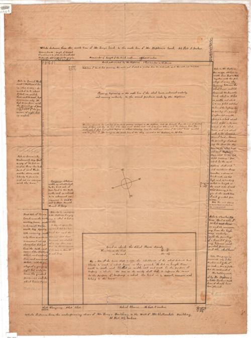
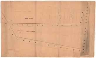
Land on Which the School House Stands
SurveyorPossibly surveyed by
Nathaniel Goodwin
American, 1782 - 1855
Dateafter 1807
MediumDrawing; black ink and pencil on paper, backed with linen
DimensionsPrimary Dimensions (image height x width): 19 1/4 x 13in. (48.9 x 33cm)
Sheet (height x width): 26 1/8 x 19 1/8in. (66.4 x 48.6cm)
Mount (height x width): 26 1/8 x 19in. (66.4 x 48.3cm)
Sheet (height x width): 26 1/8 x 19 1/8in. (66.4 x 48.6cm)
Mount (height x width): 26 1/8 x 19in. (66.4 x 48.3cm)
ClassificationsGraphics
Credit LineGift of Mrs. Flavel S. Luther
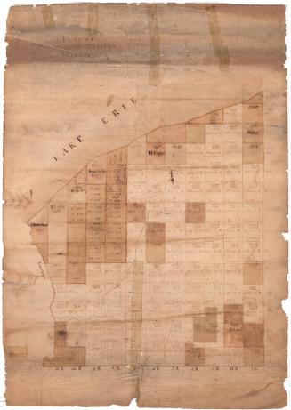
DescriptionManuscript map of the land where a schoolhouse stood in Hartford, Connecticut, including the property lines and measurements of the building, gangway and passway. The text around the map describes the history of the ownership of the schoolhouse land and the land around it.
Object number1915.6.1
MarkingsRecto, top left, handwritten in pencil: "1915.6.1"Bottom left, printed in black ink on sticker: "Map Box / 307"InscribedRecto: "Land on which the School House stands."
Measures on the front... 36F 2 In
Measures on the end... 22F 1 5/10 In
In Center::
By a Vote of the town, Sept 17 1771, the inhabitants of the school district had/
liberty to erect a a school house on this ground, "36 feet in length from/
north to south, and 22 feet in width, east and west, for the pupose of/
keeping a school. As soon as the society shall fail to improve the same/
for the purpose of keeping a school, the land is to revert, remain, and belong to the town."
Sale to Mr. Hopkins,/ Dec. 18 1793, 50 feet in/ width, from East to West,/ "together with the pri-/vilege of using the/ passway between the/ school house and Col./ Jeremiah Wadsworth's/ land, which 13 feet/ in width, and which/ is to run 75 feet west from/ the line of the highway; also/ the privilege of a passway/ of eighteen feet in width/ which is to be laid out and/ opened 35 feet in the rear/ or west of the school/ house, and is to extend/ north to the aforesaid/ piece of land; - likewise/ the privilege of extend-/ing the three feet alley/ between the school house/ and said Hopkin’s/ store, west to the said/ 18 feet passway; pro-/vided he the said/ Hopkins shall erect/ and maintain always/ thereafter, a stone or/ brick wall, six feet/ high, and extending/ 50 feet in length on/ the west side of said/ 18 feet passway, to be-/gin at the south line/ of the granted pre-/mises./ Note: The wall appears/ to have been erected on/ the wrong ground.
Sale to Charles Hop-/kins, April 11 1766, of/ 30 feet/ in width, measure-/ing from the high-/
way, westerly; - /“with the privilege/ of a three feet gang-/way, between said/ granted premises/ and the school house." / Note: The gangway/ measures only 2 feet/ 11 inches and 8/10ths of/ an inch. _ It is probable/ that the south wall of/ the building erected/ by Mr. Hopkins is/ a little further south/ than it should have/ been placed.
First sale of Town/ Land, near the north/ meeting house, made/ to Jeremiah Wads/worth, Esq. April 4,/ 1786, running south/erly, from a certain/ monument set up/ eleven feet distant/ from the South-east/ corner of the school house, 50 feet; and westerly/ from said monument,/ 30 feet;- with the pri-/vilege of a gangway / eight feet wide, be-/tween the granted/ premises and the/ school house stairs.
Gangway…8 feet, in/ width as established/ by the first sale of/ town land to Mr. Wads/
worth, and as referred/ to in subsequent con-/veyances to the said W./ and to Mess. Daniel/ W. and N. Terry./ Note_ In the conveyances/ to Mr. Hopkins, this gang-/ way is called 13 feet in/ width.It does not appear, from/ any record that has been/ found, that any of the/ passways about these/ premises are establish-/ed in any other way/ than in conveyances/ of the town to Mess. W./ H. and Terry.
Sale to Jeremiah/ Wadsworth, Esq. April/ 14, 1789 of “20 feet in/ width, from the back/ part of said Wads-/worth store, with/ liberty to pass in/ and out in common/ with the town.”
Sale to Daniel Wads/worth & Nathaniel Ter/ry. (Jan. 15.1804) de-/scribed to be “about/
27 feet in width/ from east to west,” but/ measures only 26/ feet, 10 inches; with/ the privilege of pass/ing in the gangway, north of the pre-/mises, “of eight feet in width.”
"Whole distance, from the underpinning stone of Mr. Terry's Building, to the Wall of Mr. Gallaudet's Building, / 51 Feet, 8/10 Inches."
Verso, top right, handwritten in red ink: "25934"NotesCartographic Note: No scale
Constituent Note: The map is unsigned, but the handwriting resembles that on other maps by Nathaniel Goodwin in the Connecticut Historical Society collection.
Collections
- Maps and Charts: Finding Your Place in Connecticut History
On View
Not on view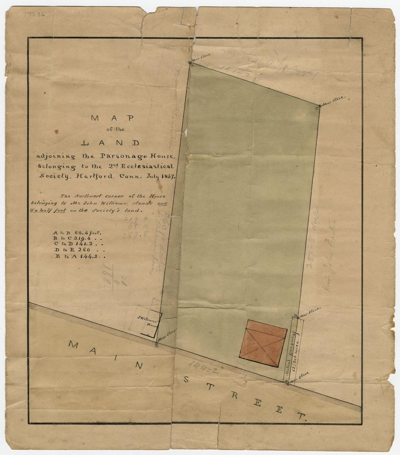

Thomas Sedgwick Steele
1881
William C. Stanton
1848