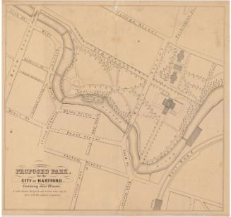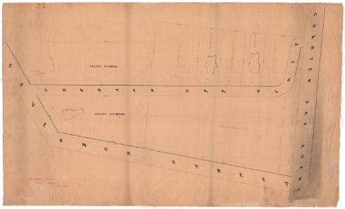
Charter Oak Place, showing property of Julius Gilman and others
SurveyorSurveyed by
Seth E. Marsh
American, about 1823 - 1878
Date1860
MediumDrawing; black ink and pencil on wove paper, lined with linen
DimensionsPrimary Dimensions (image height x width): 24 7/8 x 39in. (63.2 x 99.1cm)
Sheet (height x width): 24 7/8 x 41 5/8in. (63.2 x 105.7cm)
Mount (height x width): 24 7/8 x 41 5/8in. (63.2 x 105.7cm)
Sheet (height x width): 24 7/8 x 41 5/8in. (63.2 x 105.7cm)
Mount (height x width): 24 7/8 x 41 5/8in. (63.2 x 105.7cm)
ClassificationsGraphics
Credit LineConnecticut Museum of Culture and History collection
DescriptionMap of Governor Street, Charter Oak Place and Charter Oak Avenue in Hartford, Connecticut. Lots of land are depicted, with measurements in feet, showing the location and general shape of the buildings on them. Landowners include Julius Gilman, Robinson Bissell & Company, H. Kellogg, F.W. Cady, Nelson Kingsbury, and Nathaniel Shipman.
Object number2012.312.169
InscribedRecto, bottom left, handwritten in black ink: "SCALE 32. FEET TO THE INCH / JULY 1860 / Seth E. Marsh"NotesCartographic Note: Scale: 1 inch equals 32 feetCollections
- Maps and Charts: Finding Your Place in Connecticut History
On View
Not on view