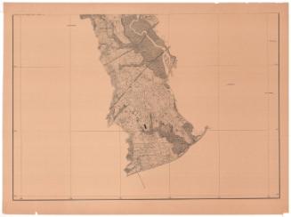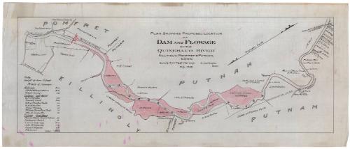
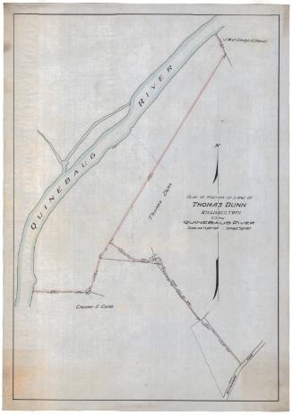
Plan Showing Proposed Location of Dam and Flowage on the Quinebaug River, Killingly, Pomfret and Putnam, Connecticut
SurveyorSurveyed by
Erastus Worthington
American, 1863 - 1953
Date1908
MediumDrawing; black ink and watercolor on drafting linen
DimensionsPrimary Dimensions (image height x width): 14 x 38 1/4in. (35.6 x 97.2cm)
Sheet (height x width): 17 1/2 x 41 3/4in. (44.5 x 106cm)
Sheet (height x width): 17 1/2 x 41 3/4in. (44.5 x 106cm)
ClassificationsGraphics
Credit LineConnecticut Museum of Culture and History collection
DescriptionMap of the Quinebaug River as it flows through Pomfret, Killingly, and Putnam, Connecticut, showing areas of flowage, landowners along the river and a proposed dam. The flowage areas appear to be colored pink, with the rest of the land divisions surrounding the river denoted with lines. At the bottom left is a list of the flowage areas in each town. Several local roads are shown, as well as the Midland Division of the New York, New Haven and Hartford Railroad.
Object number2012.312.229
InscribedRecto, top center, hand-drawn in black ink: "PLAN SHOWING PROPOSED LOCATION / OF / DAM AND FLOWAGE / ON THE / QUINEBAUG RIVER / KILLINGLY, POMFRET & PUTNAM, / CONN. / Scale 500 Feet Per Inch. E. Worthington / Engr. / Feb. 1908"Bottom left, handwritten in black ink: "Note. / Height of dam 15 feet / Areas of flowage / [list of areas of flowage]"NotesCartographic Note: Scale: 1 inch equals 500 feet
Collections
- Maps and Charts: Finding Your Place in Connecticut History
On View
Not on view
Erastus Worthington
about 1908
Erastus Worthington
1907