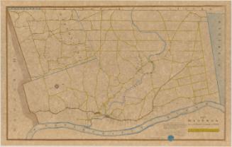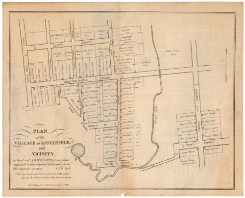
Plan of the Village of Litchfield Ct. and Vicinity
MakerCompiled by
George Catlin Woodruff
American, 1805 - 1888
PrinterPrinted by
George Hayward
Anglo-American, 1800 - 1872
Date1845
MediumLithography; black printer's ink on wove paper
DimensionsPrimary Dimensions (image height x width): 12 1/8 x 15 3/8in. (30.8 x 39.1cm)
Sheet (height x width): 13 1/4 x 16 3/8in. (33.7 x 41.6cm)
Sheet (height x width): 13 1/4 x 16 3/8in. (33.7 x 41.6cm)
ClassificationsGraphics
Credit LineConnecticut Museum of Culture and History collection
DescriptionStreet map of Litchfield, Connecticut extending from North Street to the north, Chestnut Hill Street to the east, the Bantam River to the south, and North West Street to the west. Plots of land on each street are identified by the name of the owner and the by number in the order in which they were chosen, and some of them include their size in rods.
Object number2012.312.30
MarkingsVerso, center, stamped in blue ink: "CtHi"InscribedRecto, bottom left, printed in black ink: "PLAN / of the / VILLAGE OF LITCHFIELD Ct. / and / VICINITY, / as laid out AD 1720, to 1725, from plan / annexed to the original deed, and from / the original survey's. G.C.W. 1845 / Note, The numbers prefixed, or annexed to the names / denote the Order in which the Lots were chosen. / Lith. G. Hayward. 1 Platt St., cor. Pearl St. N.Y."Verso, right side, handwritten in pencil: "Litchfield Conn. / 1720-1725"
Bottom left corner, handwritten in pencil: "Map Box / 79"
Bottom right corner, handwritten in pencil: "Map Box 79"
Map Transcription
Names of the property ownership on the map include:
On Meeting House Street:
Joseph Peat, John Man, Thomas Pier, Jacob Griswold, Jonathan Buck, Ezekiel Buck, Nathan Mitchell, Edward Culver, Timothy Seymour, Hezekiah Culver, Thomas Lee, John Buell, John Buell, Nathaniel Messenger, Samuel Lewis, J. Kilborn (20 a), Nathaniel Smith (60 a)
On South Griswold Street:
Joseph Birge, Isaac Judson, Supply Strong (Company?), Thomas Griswold, John Stoddard, Hezekiah Winchell, Timothy Stanley, John Hart, John French
On Town Hill Street:
William Goodrich, Nathaniel Smith, Nathaniel Smith, Eleazer Strong, Joseph Waller, Nathaniel Winchell, Ebenezer Woodruff, Caleb Chapel, Caleb Chapel, Jacob Gibbs, Samuel Sedgwick, Nathaniel Smith, Ezekiel Sanford, Ezekiel Sanford, Samuel Sumers, Samuel Root, Joseph Bird, Josiah Walker, Nathaniel Goodwin, John Bird, Samuel Orton, Samuel Forward, John Marsh
On North Street:
Nathaniel Woodruff, T. Lee, John Gay, T. Seymour, T. Lee, T. Seymour, N. Allen, John Buell, J. Kilborn, William Goodrich
On Town Street:
Samuel Root (next to the School Right Home Lot Division), Rev. Mr. Collins Division (next to the Ministers Right Home Lot Division), Rev. Mr. Collins Home Lot
On Chestnut Hill Street:
Benjamin Hosford, Benjamin Collins, John Calkins, Thomas Treadaway, Joseph Mason, Benjamin Webster, Joseph Gillett, Joshua Garritt, Paul Peck, John MarshNotesCartographic Note: No scale
Collections
- Maps and Charts: Finding Your Place in Connecticut History
On View
Not on view