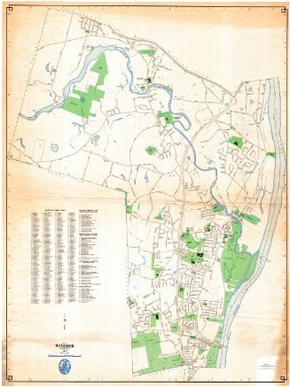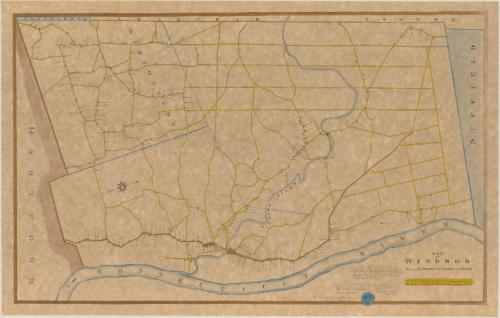
Map of Windsor Showing the Parishes, the Roads and Houses
DraftsmanDrawn by
Harvey T. Maude
American, 1885 - 1927
After a work byAfter a work by
Seth Pease
American, 1774 - 1819
MakerUnder the direction of
George R. Maude
American, 1852 - 1926
Date1906
MediumLithography; printer's ink and watercolor on wove paper
DimensionsPrimary Dimensions (image height x width): 18 5/8 x 30in. (47.3 x 76.2cm)
Sheet (height x width): 20 1/8 x 31 5/8in. (51.1 x 80.3cm)
Sheet (height x width): 20 1/8 x 31 5/8in. (51.1 x 80.3cm)
ClassificationsGraphics
Credit LineConnecticut Museum of Culture and History collection
DescriptionMap of Windsor, with Granby, Simsbury, and Farmington on the west; Suffield on the north; the Connecticut River on the east; and Hartford on the south. Wintonbury (the future Bloomfield) is shown as a separate parish. The Farmington River is identified as the Windsor River. Houses and other buildings are shown pictorially along the streets with the names of the property owners. A scale of rods and chains is at the lower right. An eight-point compass rose is at the left. The map is oriented with north at the right.
Object number1996.185.0
InscribedOn recto, lower right, printed in black ink, "MAP / OF / WINDSOR / Showing the PARISHES, the ROADS, and HOUSES"Lower right, printed in black ink, "See Town Meeting Record Vol. 4 / '19TH FEB. 1798, VOTED THAT THE SELECTMEN PROCURE A PLAN / OF THE TOWN OF WINDSOR TO BE MADE LAYING DOWN THE / SEVERAL HIGHWAYS &c &c THEREIN.' ORIGINAL PLAN DRAWN BY SETH PEASE OF SUFFIELD, WHOSE BILL FOR 19 DAYS / SURVEYING AND MAKING A PLAN OF THE TOWN OF WINDSOR / WAS 9.10.10. BILL IS DATED JULY 6TH 1798."
Lower right, in black ink, "This may certify that the above map is a true copy / of the original made by Seth Pease of Suffield, 1798. / The original is still presered in Windsor's old records / Attest. George R. Maude / Town Clerk / Windsor Aug. 10th 1906"
Lower right, in black ink, "This copy presented to the Town of Windsor / by George R. Maude, Town Clerk / Aug. 10 1906"
On verso, upper left, in penci, "Maps / Flat / 167"; lower right, in pencil, "1996.185.0"NotesCartographic Note: One inch equals 100 rods; scale also given in chains
Collections
- Maps and Charts: Finding Your Place in Connecticut History
On View
Not on view