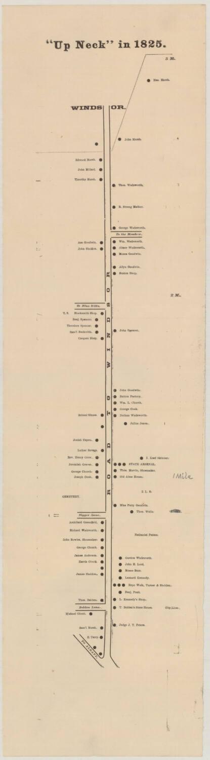
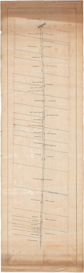
"Up Neck" in 1825.
MakerMade by
Unknown
Dateabout 1890
MediumRelief; black printer's ink on wove paper
DimensionsPrimary Dimensions (image height x width): 20 1/8 x 3 3/4in. (51.1 x 9.5cm)
Sheet (height x width): 24 x 6 3/8in. (61 x 16.2cm)
Sheet (height x width): 24 x 6 3/8in. (61 x 16.2cm)
ClassificationsGraphics
Credit LineConnecticut Museum of Culture and History collection
DescriptionMap of the Hartford, Connecticut, area known as "Up Neck." This map shows the northern part of the Neck, from Belden Lane in the south to the city line of Windsor in the north, and identifies residences, the state arsenal, and a cemetery. The names of homeowners and businesses are provided. There are several roads or lanes noted on the map, most of them labeled with the town or natural feature to which they lead ("Road to Windsor," "To Albany," "To the Meadow"). Mile 1, 2 and 3 are marked on the map as well.
Object number2012.312.15
InscribedRecto, top, printed in black ink: "'Up Neck' in 1825."Right side, handwritten in pencil: "1 Mile"
About an inch below this, the 1 Mile marker has been crossed out in pencil.
Verso, top left, handwritten in pencil: "MAP / Box / 156"
Lower right, handwritten in pencil: "Dr. Russell."
Bottom, handwritten in pencil: "1081"
Names of the property owners on the map include:
On the Road to Windsor:
Judge J. T. Peters, E. Terry, Samuel Marsh, T. Belden, L. Kennedy, Benjamin Pratt, Turner and Sheldon, Leonard Kennedy, Moses Burr, John H. Lord, Gurdon Wadsworth, James Sheldon, Harris Olcott, James Anderson, George Church, John Bowles (Shoemaker), Richard Wadsworth, Archibald Greenfield, Thomas Wells, Miss Patty Goodwin, Joseph Cook, George Church, Jeremiah Graves, Reverend Henry Grew, Luther Savage, I Lord Skinner, Thomas Marvin (Shoemaker), Josiah Capen, Julius Jones, Nathan Wadsworth, George Cook, William L. Church, John Goodwin, John Spencer, Samuel Beckwith, Theodore Spencer, Benjamin Spencer, Allyn Goodwin, Moses Goodwin, Abner Wadsworth, John Sheldon, Asa Goodwin, William Wadsworth, George Wadsworth, R. Strong Mather, Thomas Wadsworth, Timothy Marsh, John Millard, Edward Marsh, John Marsh, Hezekiel Marsh
On Belden Lane:
Michael Olcott, Thomas Belden
NotesCartographic Note: No scale
Classification Note: In terms of this project, "historical maps" refer to those made at a later date than the time period depicted.
Subject Note: This map is likely related to the book, "Up Neck" in 1825, by Gurdon Wadsworth Russell, published in 1890 by Case, Lockwood & Brainard. There is a map, also called "Up Neck" in 1825, that was included with the publication. It has the same content as this map, but the presentation is different. The typefaces used are different, and the buildings are marked with open squares, not closed circles. Most of the content appears to have been published originally in the Hartford Times.
Collections
- Maps and Charts: Finding Your Place in Connecticut History
On View
Not on view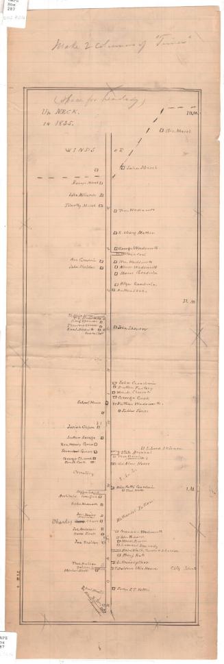


Object/Object