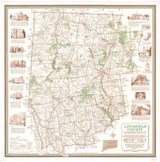
Litchfield County, Connecticut
SurveyorSurveyed by
United States Geological Survey
American, founded 1879
MakerEdited by
United States Geological Survey
American, founded 1879
PublisherPublished by
United States Geological Survey
American, founded 1879
MakerMade by
Connecticut Department of Environmental Protection
American, founded 1971
Date1979
MediumLithography; black and colored printer's inks on wove paper
DimensionsPrimary Dimensions (image height x width): 51 1/2 x 42 1/4in. (130.8 x 107.3cm)
Sheet (height x width): 58 x 44 1/4in. (147.3 x 112.4cm)
Sheet (height x width): 58 x 44 1/4in. (147.3 x 112.4cm)
ClassificationsGraphics
Credit LineMuseum purchase
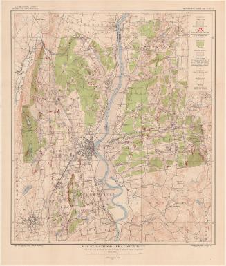
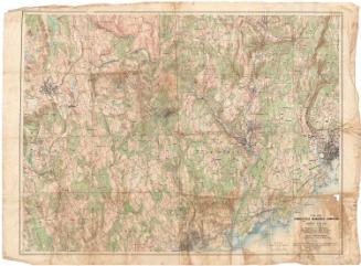
DescriptionTopographical map of New Haven County, Connecticut, showing elevation, wooded and urban areas, highways, local roads, swamps, parks, and water. Ponds, lakes, and the Housatonic, Naugatuck, and Farmington Rivers are colored blue. Shaded and open black squares are used to denote buildings.
Object number1994.251.1
MarkingsVerso, center, stamped in blue ink: "CtHi"InscribedRecto, top left, printed in black ink: "UNITED STATES / DEPARTMENT OF THE INTERIOR / GEOLOGICAL SURVEY"Top center, printed in black ink: "STATE OF CONNECTICUT / DEPARTMENT OF ENVIRONMENTAL PROTECTION / NATURAL RESOURCES CENTER"
Top right, printed in black ink: "LITCHFIELD COUNTY / CONNECTICUT / COUNTY MAP SERIES (TOPOGRAPHIC)"
Bottom left, printed in black ink: "Mapped, edited, and published by the Geological Survey / Control by USGS and NOS/NOAA / Compiled from 1:24,000-scale maps. Certain detail compiled / from aerial photographs is unchecked. See index for dates / of individual maps. Map edited 1979 / Projection and 10,000-foot grid ticks: Connecticut coordinate / system (Lambert conformal conic) / 5000-meter Universal Transverse Mercator grid ticks, zone 18 /1927 North American Datum / Gray tint indicates areas in which only landmark buildings are shown / Areas covered by dashed light-blue pattern are subject to / controlled inundation / There may be private inholdings within the boundaries of / the National or State reservations shown on this map"
Bottom left, printed in black ink: "UTM GRID AND 1978 MAGNETIC NORTH / DECLINATION AT CENTER OF SHEET"
Bottom center, printed in black ink: "SCALE 1:50 000 / CONTOUR INTERVAL 40 FEET / NATIONAL GEODETIC VERTICAL DATUM OF 1929 / THIS MAP COMPLIES WITH NATIONAL MAP ACCURACY STANDARDS / FOR SALE BY U.S. GEOLOGICAL SURVEY, RESTON, VIRGINIA 22092 / A FOLDER DESCRIBING TOPOGRAPHIC MAPS AND SYMBOLS IS AVAILABLE ON REQUEST"
Bottom right, handwritten in pencil: "MAPS / Shelf / Folio / 92577T"
Bottom right, printed in black ink: "LITCHFIELD CO., CONN. / N4128--W7253/35.5X38.5 / 1979"
Bottom right, handwritten in pencil: "MAPS / Shelf / Folio / 92577L"
Verso, center, handwritten in pencil: "92577"NotesCartographic Note: Scale: 1:50,000
Collections
- Maps and Charts: Finding Your Place in Connecticut History
On View
Not on view