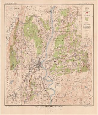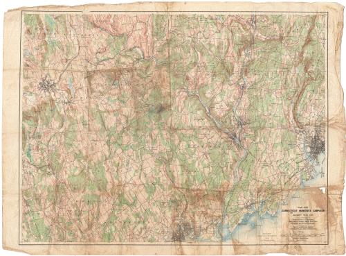
Map for Connecticut Manuever Campaign, August 10-19,1912
MakerPrepared by the
United States Geological Survey
American, founded 1879
PrintmakerEngraved by the
United States Geological Survey
American, founded 1879
PrinterPrinted by the
United States Geological Survey
American, founded 1879
Date1912
MediumLithography; colored printer's inks on wove paper
DimensionsPrimary Dimensions (image height x width): 23 3/4 x 31 1/4in. (60.3 x 79.4cm)
Sheet (height x width): 25 3/4 x 34 1/2in. (65.4 x 87.6cm)
Sheet (height x width): 25 3/4 x 34 1/2in. (65.4 x 87.6cm)
ClassificationsGraphics
Credit LineGift of the Dorset Historical Society
DescriptionMap of a portion of southwestern Connecticut with New Fairfield, Ridgefield, and Wilton on the west, New Fairfield, Brookfield, Bridgewater, Danbury, Naugatuck, and Prospect on the north, Hamden and New Haven to the east, and New Haven, Orange, Stratford, Bridgeport, Fairfield, Weston, and Wilton to the south. A portion of Long Island Sound is to the southeast. Roads and railroads are indicated. Rivers, marshes, hills, and mountains are shown. Relief is shown by contour intervals. A scale of miles and yards is at lower right.
Object number2007.84.0
MarkingsOn verso, lower left, stamped in red ink, "CtHi", in pencil, "100031"InscribedOn recto, lower right, printed in black ink, "MAP FOR / CONNECTICUT MANEUVER CAMPAIGN / AUGUST 10-19, 1912 / Prepared from U. S. Geological / Survey Maps of Danbury, Derby, New Haven, / Bridgeport, and Norwalk quadrangles. / Data for wooded areas obtained / from Chief Forester, State of Connecticut." "Contour interval 20 feet / Datum is mean sea level."NotesCartographic Note: One inch equals one mile
Collections
- Maps and Charts: Finding Your Place in Connecticut History
On View
Not on view