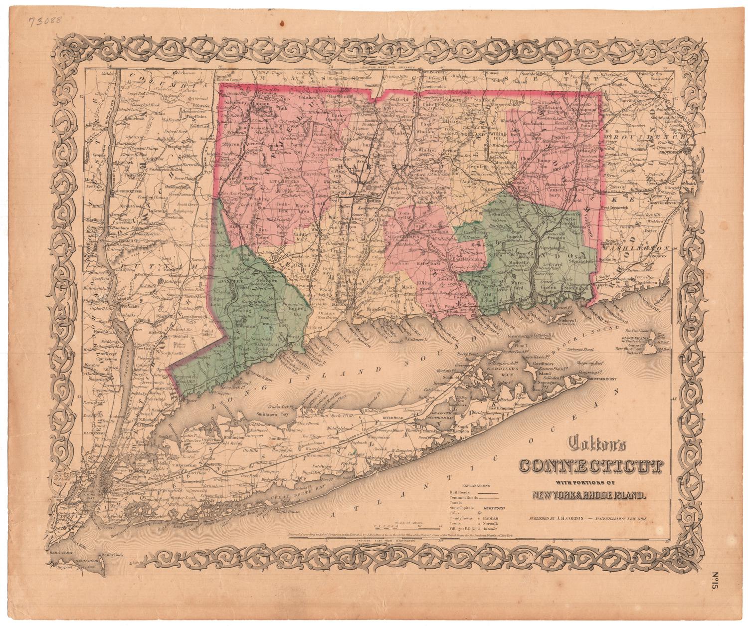
12,000 Square Miles around New York City from New Haven to Trenton, from Long Branch to the Catskills
PublisherPublished by
H. H. Lloyd & Co.
American, 1860 - 1878
Date1866
MediumLithography; black printer's ink and watercolor on wove paper, in cardboard covers
DimensionsPrimary Dimensions (section a, image height x width): 25 1/4 x 36in. (64.1 x 91.4cm)
Sheet (section a, height x width): 26 3/4 x 38 1/2in. (67.9 x 97.8cm)
Primary Dimensions (section b, image height x width): 25 x 36 1/4in. (63.5 x 92.1cm)
Sheet (section b, height x width): 26 1/2 x 38 1/2in. (67.3 x 97.8cm)
Sheet (section a, height x width): 26 3/4 x 38 1/2in. (67.9 x 97.8cm)
Primary Dimensions (section b, image height x width): 25 x 36 1/4in. (63.5 x 92.1cm)
Sheet (section b, height x width): 26 1/2 x 38 1/2in. (67.3 x 97.8cm)
ClassificationsGraphics
Credit LineGift of Mrs. Ruth Newcombe
DescriptionPocket maps depicting the area 12,000 miles north and east of New York City, with Canaan, Connecticut to the north, the western edge of Hartford County to the east, Trenton, New Jersey to the south, and Port Jervis, New York to the west. The state boundaries are marked in thick pink lines, and county divisions are marked with thinner pink lines. The states are further divided into towns, which are colored pink, yellow, blue or green. Railroad lines are prominently depicted in black, including the New York and Erie; Hudson River; Camden and Amboy; Long Island; New York and Harlem; New York and New Haven; Danbury and Norwalk; Housatonic; Naugatuck; and Hartford, Providence and Fishkill. Canals or aqueducts, cemeteries, blacksmith shops, wheelwrights, and grist and saw mills are also represented on the map. Physical features include elevation, conveyed with hachure marks; swamps and marshes; rivers; and lakes and ponds.
Object number1960.145.0a,b
InscribedFront cover, gold-tooled: "H.H. LLOYD'S / 12,000 / SQUARE MILES / AROUND / NEW YORK CITY."Recto b, bottom right, printed in black ink: "12000 SQUARE MILES / AROUND / NEW YORK CITY. / FROM NEW HAVEN / TO TRENTON / FROM LONG BRANCH / TO THE CATSKILLS / Published by / H.H. LLOYD & CO. / 21 John St. / NEW YORK / 1866"
Bottom right, printed in black ink: "Entered according to Act of Congress, in the year 1866, by H.H. Lloyd & Co., in the Clerk's Office / of the District Court of the United States for the Southern District of New York."
Bottom center, printed in black ink: list of other maps published by H.H. Lloyd & Co.
Verso, top, handwritten in pencil: list of distances between various places
NotesCartographic Note: Scale: 1 inch equals 2 1/2 miles; 1:158400
Collections
- Maps and Charts: Finding Your Place in Connecticut History
On View
Not on view