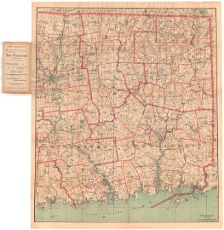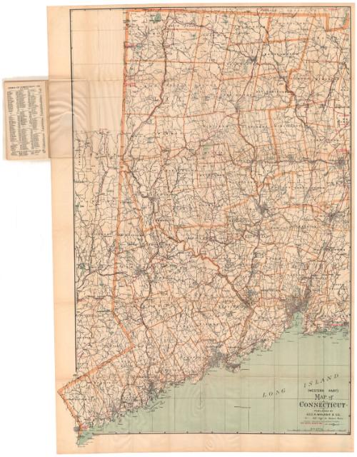
Map of Connecticut, Western Part
PrinterPrinted by
Geo. H. Walker & Co.
American, founded 1880
Date1905
MediumLithography; black and colored printer's inks on wove paper, in paper covers
DimensionsPrimary Dimensions (image height x width): 40 1/4 x 25 1/4in. (102.2 x 64.1cm)
Sheet (height x width): 41 3/8 x 27 5/8in. (105.1 x 70.2cm)
Sheet (height x width): 41 3/8 x 27 5/8in. (105.1 x 70.2cm)
ClassificationsGraphics
Credit LineMuseum purchase
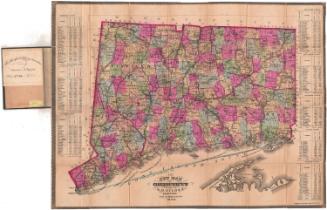
DescriptionPocket map of the western part of Connecticut, with no borders shown to the north and east, the Long Island Sound to the south, and part of New York to the west. Town divisions are marked with broken solid lines and a brownish-yellow line. Road routes between points within Connecticut and to points in Massachusetts and New York are shown in red.Physical features depicted include rivers and lakes. Also within the paper covers is an index to the names (of towns, hills, etc.) that appear on the map, and population information by county and town.
Object number1956.94.1
InscribedFront cover, top left, handwritten in black ink: "64005"Printed in brown ink: "LATEST MAP / AND / INDEX / OF / WESTERN / CONNECTICUT / PUBLISHED BY / GEO. H. WALKER & CO. / Lithographers, / 221 HIGH ST., NEAR ROWES WHARF, / BOSTON, MASS."
Back cover, bottom, printed in brown ink: "Bottom, printed in brown ink: "WALL MAPS, ATLASES, ETC. / GEO. H. WALKER & CO., / Lithographers. Photo-Lithographers. Process Cuts. / Maps and Plans Reproduced. Color Printers. / 121 HIGH STREET, BOSTON, MASS. / Near Rowes Wharf,"
Also listed: prices for other pocket road maps
Inside cover, top left, handwritten in pencil: "Maps / 64005"
Bottom, printed in brown ink: "WALL MAPS, ATLASES, ETC. / GEO. H. WALKER & CO., / Lithographers. Photo-Lithographers. Process Cuts. / Maps and Plans Reproduced. Color Printers. / 121 HIGH STREET, BOSTON, MASS. / Near Rowes Wharf,"
Also listed: prices for other pocket city maps, bird's-eye views and pocket railroad maps
Recto of first page of index, printed in black ink: "INDEX / OF THE / LATEST MAP / OF / CONNECTICUT / Published by / GEO. H. WALKER & CO. / BOSTON, MASS. / Copyright, 1893, by Geo. H. Walker & Co., Boston, Mass. / Art Publishers, / Lithographers, / Photo=Lithographers, / Engravers, / Color Printers. / SEND FOR ESTIMATES. / GEO. H. WALKER & CO. / BOSTON, MASS."
Recto, map, bottom right, printed in black ink: "(WESTERN PART) / MAP of / CONNECTICUT / PUBLISHED BY / GEO. H. WALKER & CO., / 221 High St. Boston, Mass. / COPYRIGHT 1893 & 1905 BY GEO. H. WALKER & CO., BOSTON. / BEST ROUTES SHOWN IN RED [in red ink]"
Verso, right side, handwritten in pencil: "Maps / 64005"NotesCartographic Note: Scale: 1 inch equals almost 2 miles
Collections
- Maps and Charts: Finding Your Place in Connecticut History
On View
Not on view