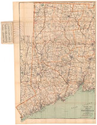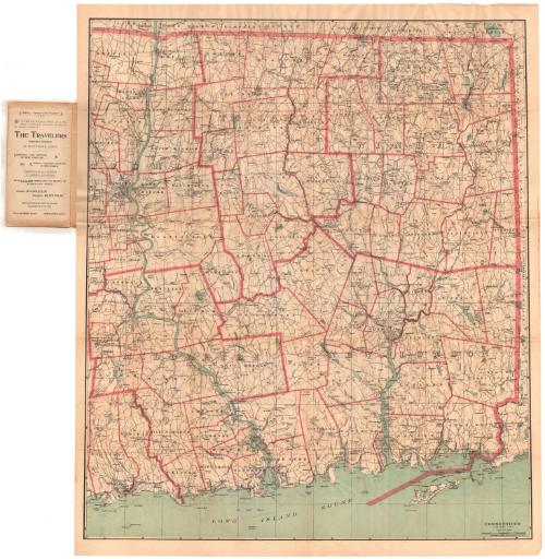
Connecticut, Eastern Part
PublisherPublished by
Geo. H. Walker & Co.
American, founded 1880
Date1893
MediumLIthography; black and colored printer's inks on wove paper, in paper folder
DimensionsPrimary Dimensions (image height x width): 32 1/4 x 27 1/4in. (81.9 x 69.2cm)
Sheet (height x width): 34 1/8 x 28 5/8in. (86.7 x 72.7cm)
Sheet (height x width): 34 1/8 x 28 5/8in. (86.7 x 72.7cm)
ClassificationsGraphics
Credit LineConnecticut Museum of Culture and History collection
DescriptionPocket map of the eastern part of Connecticut, with Massachusetts to the north, Rhode Island to the east, and the Long Island Sound to the south. County divisions are marked with thick pink lines, and town divisions with thin ones. Both are labeled. Roads are shown, as are railroad lines, including the New York, New Haven and Hartford; New London and Norther Division of the Central Vermont; and the New York and New England. Physical features depicted include elevation, conveyed with contour lines; rivers; and lakes and ponds. The map comes with an index.
Object number1988.230.0
MarkingsVerso of title page to index, bottom, stamped in blue ink: "CtHi"InscribedFront cover, printed in black ink: "LATEST MAP / and / INDEX OF / EASTERN CONNECTICUT / Published by / GEO. H. WALKER & CO. / 160 Tremont St., BOSTON, MASS. / Opposite Boston Commons"Inside cover, top left, handwritten in pencil: "Maps / 88857"
Inside cover, printed in black ink: List of maps by the publisher
Title page to index, printed in black ink: "INDEX / OF THE / LATEST MAP OF / CONNECTICUT / Published by / GEO. H. WALKER & CO. / Opp. Bostom Common. BOSTON, MASS. / Copyright, 1893, by Geo. H. Walker & Co., Boston, Mass. / Art Publishers, / Lithographers, / Photo=Lithographers, / Engravers, / Color Printers. / SEND FOR ESTIMATES. / GEO. H. WALKER & CO. / 160 Tremont Street, Opp. Boston Common, / BOSTON, MASS."
Verso of title page, bottom, handwritten in pencil: "88857"
Recto of map, bottom right, printed in black ink: "CONNECTICUT / EASTERN PART / COPYRIGHT 1893 BY GEO. H. WALKER & CO. BOSTON"NotesCartographic Note: Scale: 1/2 inch equals about 1 mile
Collections
- Maps and Charts: Finding Your Place in Connecticut History
On View
Not on view