Pocket Map of Cuba and the World
PublisherPublished by the
Fort Dearborn Publishing Company
American, active1898 - 1905
PublisherPublished by the
Pond Lily Company
American, founded 1897
Date1899
MediumLithography; black and colored printer's inks on wove paper, with cardboard covers
DimensionsPrimary Dimensions (image height x width): 13 1/8 x 20 3/8in. (33.3 x 51.8cm)
Sheet (height x width): 13 7/8 x 21 1/4in. (35.2 x 54cm)
Sheet (height x width): 13 7/8 x 21 1/4in. (35.2 x 54cm)
ClassificationsGraphics
Credit LineGift of Mrs. Almira A. Bissell
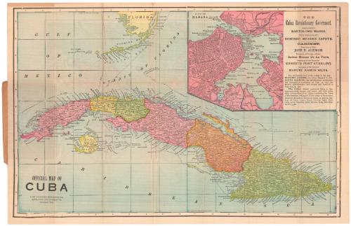
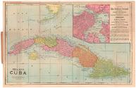
DescriptionMap of Cuba on one side of the sheet, with the southern tip of Florida to the north and the Caribbean to the south, during Cuba's War of Independence (from Spain). The country is divided into six provinces and one island (Isla de Pinos, now referred to as Isla de la Juventud). Cities and towns are marked with circles, and what are probably roads with black lines. Elevation is conveyed with hachure marks, and what are probably regular ship routes are marked with broken solid lines and labeled with their destination (New York, Mexico, etc.). In the top right corner is an inset map of Havana, showing the layout of the city streets, although the streets themselves are not labeled. Text identifying the leaders of the revolutionary government and the size of the army is also shown.
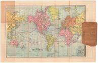
On the other side of the sheet is a map of the world, showing the continents with countries labeled but not demarcated. Lines between various coastal cities are marked with the distances between them.
The map was originally enfolded within two cardboard covers, one of which gives the title of the map and has information about the Pond Lily Company, which was the retailer of the map.
Object number1936.33.0
MarkingsFront cover, top, typed in red ink on sticker: "T Box / Maps / #31" [crossed out in pencil]Front cover, top, handwritten in pencil on sticker: "Ephem / (advert) [?]"InscribedRecto, front cover, top left printed in black ink: "[667]"
Top, printed in black ink: "[illegible, covered by sticker] Cuba and The World"
Bottom, printed in black ink: "Trace the movements of the Army and Navy / on this Map, and don't forget to give us a chance / when you have anything in our line to be done."
Bottom, printed in black ink: "The Pond Lily Co., / 123 Church Street, / New Haven, Conn."
Back cover, bottom, printed in black ink: "The Pond Lily Co., / 123 CHURCH STREET. NEW HAVEN, CONN. / WE ALSO HAVE OFFICES IN THE FOLLOWING / CITIES / [illegible] Derby. Hartford. Waterbury. New London"
Recto of map, bottom left, printed in black ink: "OFFICIAL MAP OF / CUBA / FORT DEARBORN PUBLISHING CO. / ENGRAVERS AND PUBLISHERS, / CHICAGO, ILL."
Verso of map, bottom, printed in black ink: "MAP OF / THE WORLD, / ON MERCATORS PROJECTION."NotesCartographic Note: Scale, Map of Cuba: 1 1/8 inches equal 40 miles
Collections
- Maps and Charts: Finding Your Place in Connecticut History
On View
Not on view