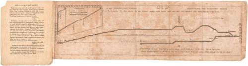
Profile of the Navigation from Northampton to Hartford
SurveyorSurveyed by
Unknown
PrintmakerEngraved by
Unknown
PublisherPublished by
Unknown
DateProbably 1828
MediumEngraving; black printer's ink on wove paper, with paper cover
DimensionsPrimary Dimensions (image height x width): 5 1/8 x 19 1/2in. (13 x 49.5cm)
Sheet (height x width): 6 1/8 x 20 1/4in. (15.6 x 51.4cm)
Other (Cover, height x width): 6 3/4 x 5 3/8in. (17.1 x 13.7cm)
Sheet (height x width): 6 1/8 x 20 1/4in. (15.6 x 51.4cm)
Other (Cover, height x width): 6 3/4 x 5 3/8in. (17.1 x 13.7cm)
ClassificationsGraphics
Credit LineConnecticut Museum of Culture and History collection
DescriptionProfiles, including locks, of the Farmington Canal and Hampshire and Hampden Canal. The top profile shows the canals from the Connecticut River north of Northampton, Massachusetts, to New Haven, Connecticut. The bottom one shows the profile from the Connecticut River north of Northampton to Hartford, Connecticut. In the top left is a profile of the number of locks from Horthampton to New Haven and Northampton to Hartford. The sheet is adhered to a paper cover that has an explanation of the profile printed on the inside.
Object number1989.173.2
MarkingsVerso, center, stamped in blue ink: "CtHi"InscribedFront cover, top left, handwritten in pencil: "T Box / Maps / #1"Top, handwritten in black ink: "Simeon Hart"
Left side, handwritten in pencil: "green silk"
Recto, top, printed in black ink: "PROFILE, 1. / OF THE FARMINGTON CANAL AND OF THE HAMPSHIRE AND HAMPDEN CANAL / From Northampton to New Haven, by the Canal, eighty seven miles: Rise and Fall five hundred and twenty feet, by sixty Locks."
Top left, printed in black ink: "PROFILE. 2. / Shewing, at one view the / number of LOCKS from / NORTHAMPTON to NEW-HAVEN / and from / NORTHAMPTON to HARTFORD"
Bottom, printed in black ink: "PROFILE OF THE NAVIGATION FROM NORTHAMPTON TO HARTFORD / From Northampton to Hartford, by Connecticut River, forty five miles: Fall ninety feet by ten Locks."
Verso, center, handwritten in pencil: "89736"NotesCartographic Note: No scale
Constituent Note: This map appears to have been issued together with A Map Exhiibiting the Farmington & Hampden & Hampshire Canals. If so, it was probably surveyed by Davis Hurd and engraved and published by N. & S.S. Jocelyn in New Haven in 1828.
Subject Terms
Collections
- Maps and Charts: Finding Your Place in Connecticut History
On View
Not on view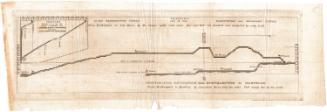


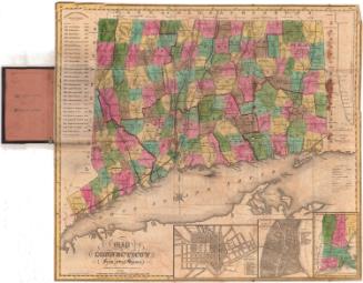
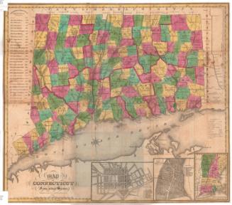
H. F. Sumner & Co.
1833