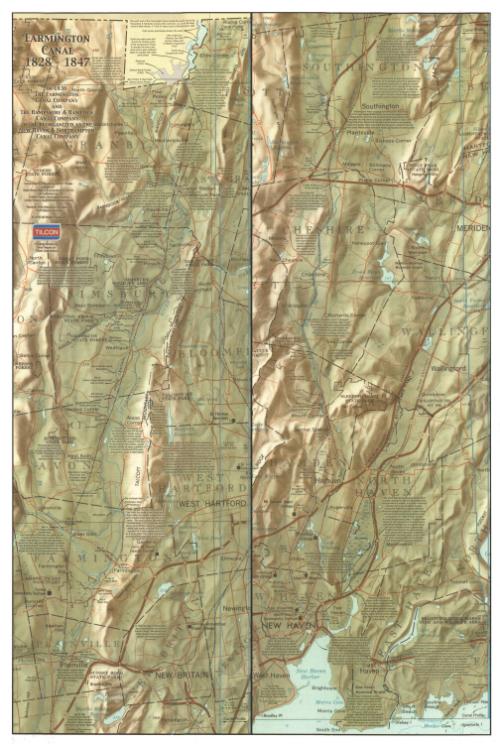

Map of the Farmington Canal
MakerCompiled by
Carl E. Walter
American, born 1938
DraftsmanIllustrated by
Ruth Sharp Hummel
American, born 1930
Date2000
MediumOffset lithography; black and colored inks on paper
DimensionsPrimary Dimensions (left side, image height x width): 36 x 12in. (91.4 x 30.5cm)
Primary Dimensions (right side, image height x width): 36 x 12in. (91.4 x 30.5cm)
Sheet (image height x width): 36 x 24in. (91.4 x 61cm)
Primary Dimensions (right side, image height x width): 36 x 12in. (91.4 x 30.5cm)
Sheet (image height x width): 36 x 24in. (91.4 x 61cm)
ClassificationsGraphics
Credit LineGift of Carl E. Walter
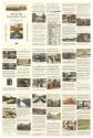
DescriptionMap of the Farmington Canal, split into two sections and overlaid onto later relief maps of the area. On the left is the canal as it flowed through Connecticut from the Hampshire and Hampden Canal at the state line of Massachusetts to just south of Plainville, Connecticut. On the right is the canal as it flowed from south of Plainville to New Haven, Connecticut. The canal is color-coded for which parts remained as of 2000, when the map was published, and which are gone. Locks, culverts, drains and other structures along the canal are labeled, with a brief description of the object. These, too, are color-coded for which structures remain and which do not. On the right side of each map is a profile of the canal. Various facts about the canal are scattered across the map. The verso contains "historical vignettes" describing the canal as it ran through towns in Connecticut. The text is accompanied by images depicting some aspect of the canal in each town.
Object number2012.455.1
InscribedRecto, top left, printed in black ink: "FARMINGTON CANAL / 1828-1847"Top left, printed in black ink: "IN 1836 / THE FARMINGTON / CANAL COMPANY / AND / THE HAMPSHIRE & HAMPDEN / CANAL COMPANY / WERE REORGANIZED AS THE / NEW HAVEN & NORTHAMPTON / CANAL COMPANY"
Top left, printed in black ink: "Canal Map and Notes by Carl E. Walter / based on / State Base Map of Connecticut (CT0017) / as published by / United States Geological Survey / United States Department of the Interior"
Top left, printed in black ink: Reverse Side Historical Vignettes by / Ruth Sharp Hummel"
Top left, printed in black ink: "© 2000 All Rights Reserved"
Top left, printed in black, blue, red and grey ink: "TILCON"
Top left, printed in black ink: "Printing funded by / your friends at / Tilcon Connecticut"
Verso, top left, printed in black ink: "MAP OF THE / FARMINGTON CANAL / Historical Vignettes by Ruth Sharp Hummel / Canal Map with Notes by Carl E. Walter / © 2000 all rights reserved"
Top left, printed in black, blue, red and grey ink: "TILCON"
Top left, printed in black ink: "Printing funded by your friends at Tilcon Connecticut"
NotesCartographic Note: No scale
Collections
- Maps and Charts: Finding Your Place in Connecticut History
On View
Not on view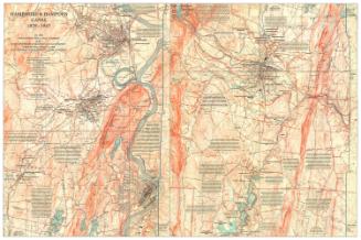
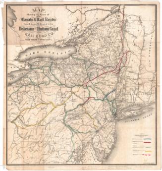


H. F. Sumner & Co.
1833