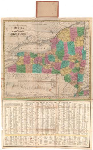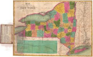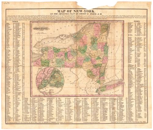
Map of New-York
MakerCopyrighted by
Sidney E. Morse
American, 1794 - 1871
PrinterPrinted by
Sidney Babcock
American, 1797 - 1888
PublisherPublished by
N. & S. S. Jocelyn
American, founded 1818
Date1828
MediumEngraving; black printer's ink and watercolor on wove paper
DimensionsPrimary Dimensions (image height x width): 11 7/8 x 14 1/2in. (30.2 x 36.8cm)
Sheet (height x width): 13 1/8 x 15 1/4in. (33.3 x 38.7cm)
Sheet (height x width): 13 1/8 x 15 1/4in. (33.3 x 38.7cm)
ClassificationsGraphics
Credit LineConnecticut Museum of Culture and History collection
DescriptionMap of the state of New York, with Upper Canada to the north; Vermont, Massachusetts and Connecticut to the east; Pennsylvania and New Jersey to the south; and Lake Erie to the west. The state is divided into counties, with the locations of towns and cities appearing as numbered circles that corresponds with the index that appears around the sides of the map. There is an inset of the Greater New York City area. Physical features depicted include elevation, conveyed with hachure marks; rivers; and lakes.
Object number1960.140.0
MarkingsVerso, center, stamped in blue ink: "CtHi"InscribedRecto, top left corner, handwritten in black ink: "67678"Top center, printed in black ink: "MAP OF NEW-YORK. / ON THE IMPROVED PLAN OF SIDNEY B. MORSE, A.M."
Bottom left, printed in black ink: "[Entered according to act of Congress, the fifth of May, 1827, by SIDNEY E. MORSE, of the State of Connecticut.]"
Bottom center, printed in black ink: "S. BABCOCK, Printer--New-Haven, Conn."
Bottom right, printed in black ink: "Published by N. & S.S. JOCELYN, New-Haven, Conn. 1828"
Verso, center, handwritten in pencil: "67678"NotesCartographic Note: Scale: 1 inch equals about 45 miles
Collections
- Maps and Charts: Finding Your Place in Connecticut History
On View
Not on view