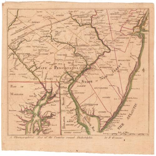
A Chorographical Map of the Country round Philadelphia
DraftsmanDrawn by
Bernard Romans
American, 1741 - 1784
Date1778
MediumEngraving; black printer's ink and watercolor on laid paper
DimensionsPrimary Dimensions (image height x width): 11 5/8 x 13in. (29.5 x 33cm)
Platemark (height only): 12 1/2in. (31.8cm)
Sheet (height x width): 13 3/4 x 14in. (34.9 x 35.6cm)
Platemark (height only): 12 1/2in. (31.8cm)
Sheet (height x width): 13 3/4 x 14in. (34.9 x 35.6cm)
ClassificationsGraphics
Credit LineConnecticut Museum of Culture and History collection
DescriptionMap of the region near Philadelphia, Pennsylvania, showing the counties of Lancaster, Berks, North, Hampton, Bucks, Philadelphia, Chester and York in Pennsylvania; Salem, Cumberland, Gloucester, Burlington, Monmouth, Middlesex, Morris, Essex and Berge Counties in New Jersey; and New Castle and Kent Counties in Delaware. Part of Maryland is depicted in the lower left corner. The Grand American Winter Camp of January 1778 is shown in Valley Forge, Pennsylvania. Towns are marked with circles, and churches and what are probably town halls or courthouses are noted with small buildings. Physical features include bays, rivers and elevation, conveyed with clusters of peaks.
Object number1991.192.0
MarkingsRecto, top left corner, printed in black ink on sticker: "MAPS / Box / 254"InscribedRecto, bottom, printed in black ink: A Chorographical Map of the Country round Philadelphia by B - Romans"Verso, top left, handwritten in pencil: "Maps / Flat / 63"
Center, handwritten in pencil: "90456"
Bottom left, handwritten in pencil: "CONN. HISTORICAL SOCIETY"NotesCartographic Note: Scale: 1 inch equals about 12 miles
Collections
- Maps and Charts: Finding Your Place in Connecticut History
On View
Not on view


Kellogg & Bulkeley
1910-1915