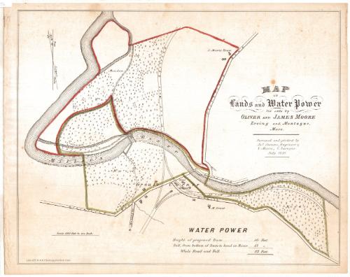
Map of Lands and Water Power for sale by Oliver and James Moore Erving and Montague, Mass.
SurveyorSurveyed by
James Stevens
American, active 1856
SurveyorSurveyed by
S. Moore
American, active 1856
PrinterPrinted by
E.B. & E.C. Kellogg
American, 1840 - 1867
Date1856
MediumLithography; printer's ink and watercolor on wove paper
DimensionsPrimary Dimensions (image height x width): 14 x 17 5/8in. (35.6 x 44.8cm)
Sheet (height x width): 14 3/4 x 18 3/4in. (37.5 x 47.6cm)
Sheet (height x width): 14 3/4 x 18 3/4in. (37.5 x 47.6cm)
ClassificationsGraphics
Credit LineMuseum purchase
DescriptionMap showing property located near Grout's Corner on Miller's River in Erving and Montague, Massachusetts. The Vermont and Massachusetts Railroad runs through the property; a hotel and a railroad depot are shown on Wendell Road at Grout's Corner. The roads to Greenfield, Northfield, Montague, and Erving are also indicated, as well as a proposed dam and canal, and the houses of M. Grout and J. Moore. Small trees are used to indicate that most of the land is wooded; a meadow is also indicated. A compass showing "True North" and "North by Compass" is at the upper left.
Object number1993.171.0
MarkingsOn verso, stamped in blue ink, "CtHi"InscribedOn recto, upper right, printed in black ink, "MAP / OF / Lands and Water Works / for sale by / OLIVER AND JAMES MOORE / Erving and Montague, / Mass."; lower right, printed in black ink, "WATER POWER / Height of proposed Dam........10 Feet / Fall, from bottom of Dam to bend in River.......17 [Feet] / Whole Head and Fall........ 27 Feet."On verso, upper left, in pencil, "Maps / Flat / 144"; center, "91684"NotesCartographic Note: 1 inch = 400 feet
Collections
- Maps and Charts: Finding Your Place in Connecticut History
On View
Not on view


H. F. Sumner & Co.
1833