Skip to main content
Collections
Objects
People
Thesaurus
Favorites
Advanced Search
Home
People
S. Moore
Expand
S. Moore
Previous
Next
Museum purchase, 1993.171.0 © 2012 The Connecticut Historical Society.
S. Moore
American, active 1856
Names
S. Moore
View All Works
Biography
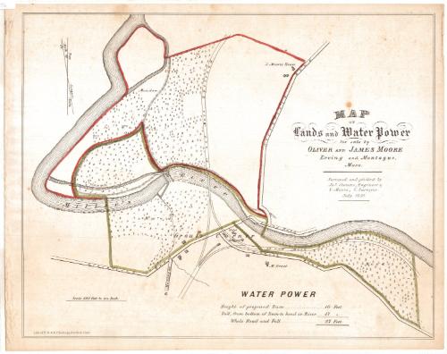
S. Moore was the County Surveyor for Franklin County, Massachusetts in 1856. His name appears on an 1856 map of Erving and Montague Massachusetts.
Person Type
Individual
Discover More
James Stevens
American, active 1856
View All Works
Related to James Stevens
(1)
Image Not Available
for D. S. Osborn
D. S. Osborn
American, active 1855 - 1856
View All Works
Related to D. S. Osborn
(1)
Image Not Available
for H. C. Osborn
H. C. Osborn
American, active 1856 - 1857
View All Works
Related to H. C. Osborn
(2)
Image Not Available
for H. F. Walling's Map Establishment
H. F. Walling's Map Establishment
American, founded 1856
View All Works
Related to H. F. Walling's Map Establishment
(1)
E. M. Woodford
American, 1824 - 1862
View All Works
Related to E. M. Woodford
(12)
Kenyon Studio
View All Works
Related to Kenyon Studio
(2)
Roger Sherman
American, 1721 - 1793
View All Works
Related to Roger Sherman
(1)
Asenath King
American, 1764 - 1859
View All Works
Related to Asenath King
(1)
Joseph E. Baker
American, 1837 - 1914
View All Works
Related to Joseph E. Baker
(2)
Image Not Available
for Bates Hoyt How
Bates Hoyt How
American, born 1776
Image Not Available
for E. P. Gerrish
E. P. Gerrish
American, active 1855 - 1856
View All Works
Related to E. P. Gerrish
(1)
Asa P. Fitch
American, 1848 - 1916
View All Works
Related to Asa P. Fitch
(2)