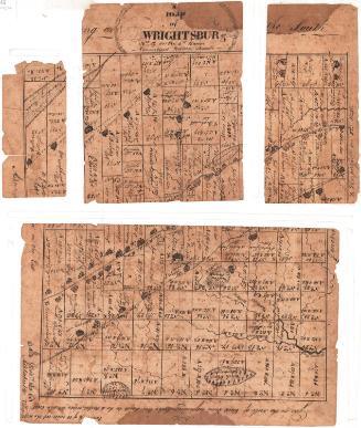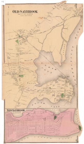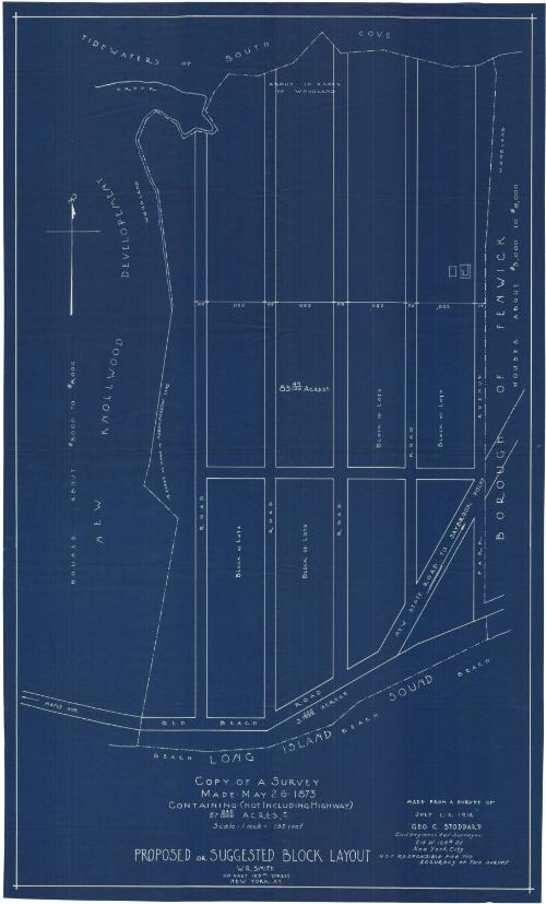
Proposed or Suggested Block Layout, Borough of Fenwick
SurveyorSurveyed by
George C. Stoddard
American, 1854 - 1922
Date1912
MediumBlueprint; cyanotype on paper
DimensionsPrimary Dimensions (image height x width): 28 1/8 x 16 3/4in. (71.4 x 42.5cm)
Sheet (height x width): 29 x 17 5/8in. (73.7 x 44.8cm)
Sheet (height x width): 29 x 17 5/8in. (73.7 x 44.8cm)
ClassificationsGraphics
Credit LineGift of Newton C. Brainard
DescriptionBlueprint of a proposed block layout east of the new Knollwood development in Fenwick, Old Saybrook, Connecticut, with South Cove to the north, Park Avenue to the east, the Long Island Sound to the south, and an unnamed road to the west. There are five roads running north-south, with one running east-west, and undivided blocks of land in between. The width measurements in feet are provided for the roads and blocks, and the area in acres for one block which presumably applies to the others.
Object number1954.34.1
InscribedRecto, bottom, in white on blue: "COPY OF A SURVEY / MADE- MAY 26- 1873 / CONTAINING- (NOT INCLUDING HIGHWAY) / 87 045/1000 ACRES, +- / Scale 1 inch = 132 feet / PROPOSED or SUGGESTED BLOCK LAYOUT / W.R. SMITH / 110 EAST 125TH STREET / NEW YORK, N.Y."Bottom right, in white on blue: "MADE FROM A SURVEY OF / JULY 1,-2, 1912 / GEO. C. STODDARD / Civil Engineer And Surveyor. / 215 W. 125th St / New York City / NOT RESPONSIBLE FOR THE / ACCURACY OF THIS SURVEY."
Verso, top left corner, handwritten in black ink: "63240"
Top left, handwritten in pencil: "Loaned of Mr / Brainard"NotesCartographic Note: Scale: 1 inch equals 132 feet
Collections
- Maps and Charts: Finding Your Place in Connecticut History
On View
Not on view