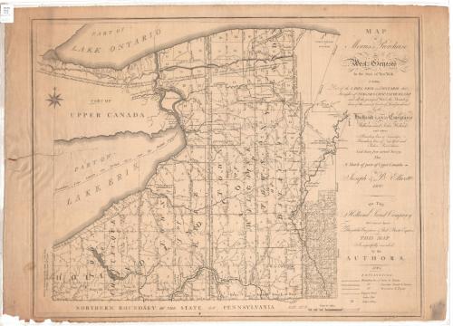
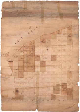
Map of Morris's Purchase or West Geneseo in the State of New York
SurveyorSurveyed by
Joseph Ellicott
American, 1760 - 1826
Date1804
MediumEngraving; black printer's ink on laid paper
DimensionsPrimary Dimensions (image height x width): 20 1/2 x 26 1/2in. (52.1 x 67.3cm)
Platemark (height x width): 20 7/8 x 26 7/8in. (53 x 68.3cm)
Sheet (height x width): 21 3/4 x 30 1/4in. (55.2 x 76.8cm)
Platemark (height x width): 20 7/8 x 26 7/8in. (53 x 68.3cm)
Sheet (height x width): 21 3/4 x 30 1/4in. (55.2 x 76.8cm)
ClassificationsGraphics
Credit LineConnecticut Museum of Culture and History collection
DescriptionMap of land in West Geneseo, New York, owned by Robert Morris, extending from Lake Ontario to the north, the Eastern Bounds to the east, Pennsylvania to the south and Lake Erie to the west. The land is divided into sixteen rows and fifteen columns of squares, with each square numbered with the row it is in. Running along the bottom row of squares, from right to left, each column is labeled with a range number. The squares in the first row along the bottom and the column farthest to the right are also labeled with measurements in chains. Reservations are denoted and labeled, as are roads, some rivers and other physical features. To the right of the map image area is the explanation, which provides information about the depiction of the boundary lines between tracts and towns; the boundary lines between townships, tracts and towns; the boundary lines between reservations and tracts; wagon roads; "Indian Paths;" and "Indian Villages." The latitude is given as 42 degrees north.
Object number2012.312.81
MarkingsRecto, top left, printed in black on sticker: "MAPS / Box / 212"InscribedRecto, right side, printed in black ink: "MAP / of Morris's Purchase / of / West Geneseo / In the State of New York: / Exhibiting / Part of the LAKES ERIE and ONTARIO, the / Straights of NIAGARA, CHAUTAQUE LAKE / and all the principal Waters, the Boundary / lines of the several Tracts of Land purchased / by the / Holland LAND Company / William and John Willink / and others. / Boundary lines of Townships: - / Boundary lines of New York and / Indian Reservations: / Laid down from actual Survey: / Also / A Sketch of part of Upper Canada- / by / Joseph & B. Ellicott / 1800. / TO THE / Holland Land Company / their General Agents / Theophilus Cazenove & Paul Busti Esquires / THIS MAP / Is respectfully inscribed / by the / AUTHORS. / 1804"Right side, printed in black ink: "EXPLANATION. / [line] Boundary line of Tracts & Towns / [line] Do. Townships Tracts & Towns / [line] Do. Reservations & Tracts / [line] Waggon Road / [line] Indian Path / [line] Indian Village"
Verso, left side, handwritten in black ink: "Presented to George Brinckerhoff by J. Milnor [?] Jr. Engr.- / Batavia October 8th 1828-"
NotesCartographic Note: 3 inches equals about 15 1/2 miles
Collections
- Maps and Charts: Finding Your Place in Connecticut History
On View
Not on view


Silvermine Production
1973