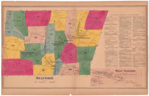
Stafford
SurveyorSurveyed by
Ormando Willis Gray
American, born 1829
PrinterPrinted by
Kellogg & Bulkeley
American, 1867 - 1990
PublisherPublished by
C. G. Keeney
American, about 1810 - 1888
Date1869
MediumLithography; black printer's ink and watercolor on wove paper
DimensionsPrimary Dimensions (image height x width): 16 1/8 x 28 1/4in. (41 x 71.8cm)
Sheet (height x width): 18 1/4 x 28 3/8in. (46.4 x 72.1cm)
Sheet (height x width): 18 1/4 x 28 3/8in. (46.4 x 72.1cm)
ClassificationsGraphics
Credit LineConnecticut Museum of Culture and History collection
DescriptionMap of the town of Stafford, Connecticut, divided into eleven numbered districts, colored and divided by broken solid lines. Roads are shown but are not labeled. Small squares denote the locations of buildings, which are labeled with the names of property owners. The New London Norther Railroad runs north-south through the town. To the right is a business directory of Stafford, below which is an inset map of West Stafford.
Object number2006.122.0
MarkingsRecto, bottom left corner, printed in black ink on sticker: "Maps / Box / 336 / (99369)"Verso, bottom right corner, stamped in blue ink: "THE CONNECTICUT / HISTORICAL SOCIETY"InscribedRecto, bottom left, printed in black ink: "STAFFORD"
Bottom right, printed in black ink: "WEST STAFFORD"NotesCartographic Note: Scale, Stafford: about 1/2 inch equals 80 rods; West Stafford: about 1/2 inch equals 25 rods
Collections
- Maps and Charts: Finding Your Place in Connecticut History
On View
Not on view