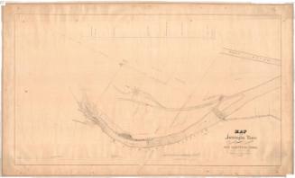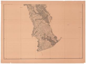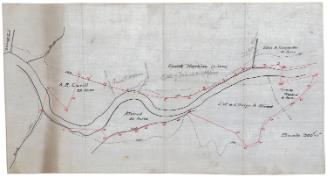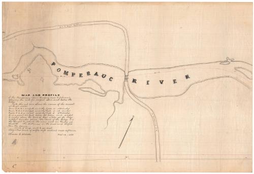
Map and Profile of the Pomperaug River Crossing near I. Johnson's...
DraftsmanDrawn by
Charles E. Webster
American, 1842 - 1920
Date1868
MediumDrawing; black ink on wove paper
DimensionsPrimary Dimensions (image height x width): 14 1/4 x 21in. (36.2 x 53.3cm)
Sheet (height x width): 14 1/4 x 21in. (36.2 x 53.3cm)
Sheet (height x width): 14 1/4 x 21in. (36.2 x 53.3cm)
ClassificationsGraphics
Credit LineConnecticut Museum of Culture and History collection
DescriptionManuscript map of the Pomperaug River in Southbury, Connecticut, showing the road between South Britain and Southbury as it crosses the river. The direction in which the river flows is marked with arrows, and a red line shows the course of the current at high water. Below the map is the profile of the river and high water line. Distances in feet and the amounts of fall in inches between points along the river (marked with letters A-E on the map and profile) are explained below the title.
Object number2005.186.0
InscribedRecto, left side, handwritten in black ink: "MAP AND PROFILE / of the Pomperaug River Crossing near I. Johnson's / showing the river for 500 feet above and below the bridge"Left side, handwritten in black ink: [Explanation of red line, letters and scale]
Left side, handwritten in black ink: "Charles E. Webster Novr. 18, 1868"
Bottom left, handwritten in pencil: "[99010]"
NotesCartographic Note: Scale: 1 inch equals 50 feet
Collections
- Maps and Charts: Finding Your Place in Connecticut History
On View
Not on view