A New and Correct Map of the United States of North America
PrinterEngraved by
Abel Buell
American, 1742 - 1784
PrinterPrinted by
Abel Buell
American, 1742 - 1784
PublisherPublished by
Abel Buell
American, 1742 - 1784
Date1784
MediumEngraving; printer's ink on laid paper
DimensionsSheet (height x width): 43 1/4 × 48 3/4in. (109.9 × 123.8cm)
Frame (height x width x depth): 45 3/4 × 50 3/4 × 2 3/4in. (116.2 × 128.9 × 7cm)
Frame (height x width x depth): 45 3/4 × 50 3/4 × 2 3/4in. (116.2 × 128.9 × 7cm)
ClassificationsGraphics
Credit LineConnecticut Museum of Culture and History collection
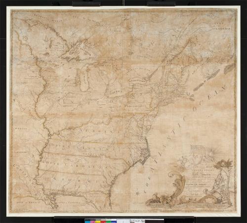
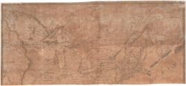
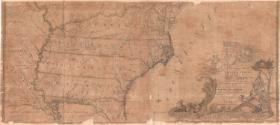
DescriptionGeopolitical map of the United States following the Revolutionary War, in two separate pieces, (.a) and (.b). It shows new boundaries as determined at the Treaty of Paris: to the north is Canada's James Bay; to the east, the Gulf of St. Lawrence and the Atlantic Ocean; to the south, the Gulf of Mexico and what was then known as the Gulf of Florida; to the west, lands beyond the Mississippi River. Canadian places named on the map include Quebec, Nova Scotia, Labrador, and the boundary of Hudson Bay. The American states named on the map are Massachusetts, Hampshire, Vermont, Rhode Island, Connecticut, New York, New Jersey, Pennsylvania, Delaware, Maryland, Virginia, North Carolina, South Carolina and Georgia. Maine, Arkansas, Louisiana and Florida also appear on the map, but were not states at the time.
The cartouche appears in the lower right corner of (.b). On the left of the cartouche, a winged figure blowing a horn heralds the American flag, lit by the rising sun. The figure represents Minerva, the Roman goddess of wisdom, commerce, and war. On the flag are thirteen stars, arranged in five rows, and thirteen stripes. A winged cherub holds up a fringed, oval item (a piece of fabric, possibly). On it is the Connecticut State Seal with three grapevines. To the right of the title, a female figure representing Liberty sits under a tree, holding a liberty cap on a pole in her right hand. In her left, she holds a globe inscribed "America." At her feet is a scroll inscribed with the first Independence Day.
The cartouche appears in the lower right corner of (.b). On the left of the cartouche, a winged figure blowing a horn heralds the American flag, lit by the rising sun. The figure represents Minerva, the Roman goddess of wisdom, commerce, and war. On the flag are thirteen stars, arranged in five rows, and thirteen stripes. A winged cherub holds up a fringed, oval item (a piece of fabric, possibly). On it is the Connecticut State Seal with three grapevines. To the right of the title, a female figure representing Liberty sits under a tree, holding a liberty cap on a pole in her right hand. In her left, she holds a globe inscribed "America." At her feet is a scroll inscribed with the first Independence Day.
Object number1950.553.0
InscribedRecto of part .a, top left, printed in black ink: "Longitude West from London"Recto of part .b, lower right, printed in black ink: "A / NEW and correct MAP / of the / UNITED STATES / of / North America / Layd down from the Latest observations and / best Authorities agreeable to the PEACE of / 1783 / Humbly inscribed to his Excellency the / Governor and Company / of the STATE of CONNECTICUT / By their / Most Obedient / and very humble servant / Abel Buell"
Lower right, printed in black ink: "NEW HAVEN Published according to Act of ASSEMBLY"
Lower center, printed in black ink: "English Miles 60 1/2 to a Degree"
Lower left, printed in black ink: "Longitude West from Philadelphia"
Lower right, printed in black ink: "Longitude East from Philadelphia"
Center bottom, printed in black ink: "Meridian of Philadelphia"
The map is framed and the verso was unavailable at the time of cataloging.
NotesCartographic Note: Scale: 60 1/2 English miles to a Degree
Collections
- Maps and Charts: Finding Your Place in Connecticut History
On View
Not on view