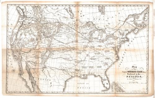
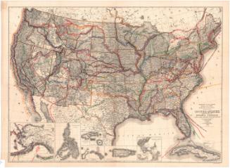
Map of the Proposed Northern Route for a Railroad to the Pacific
DraftsmanDrawn by
Edwin F. Johnson
American, 1803 - 1872
PrinterLithographed by
E.C. Kellogg & Co.
American, 1851 - 1854
Date1853
MediumLithography; black printer's ink on wove paper
DimensionsPrimary Dimensions (image height x width): 20 5/8 x 32 5/8in. (52.4 x 82.9cm)
Sheet (height x width): 22 x 34 7/8in. (55.9 x 88.6cm)
Sheet (height x width): 22 x 34 7/8in. (55.9 x 88.6cm)
ClassificationsGraphics
Credit LineConnecticut Museum of Culture and History collection
DescriptionMap of the United States and part of Canada, primarily depicting a proposed railroad line from Chicago to Bellingham Bay, Washington. Other westward-bound railroad lines are shown, including one from Chicago to Astoria, Oregon; from Memphis to San Francisco; from New Orleans to San Diego; and from St. Louis to Walker's Pass, California. Direct routes between two places are denoted with broken solid lines. Physical features depicted include elevation, conveyed with hachure marks; lakes, rivers, islands, bays and gulfs.
Object number2012.312.202
MarkingsRecto, top and bottom left corners, printed in black ink on stickers: "MAPS / Drawer / 8"InscribedRecto, lower right, printed in black ink: "Map / OF THE / Proposed NORTHERN ROUTE for a / Railroad to the / PACIFIC, / by Edwin F. Johnson, C.E. / 1853"Bottom center, printed in black ink: "Entered according to Act of Congress, in the year 1853, by Edwin F. Johnson, in the Clerk's office of the District Court of Connecticut"
Bottom right, printed in black ink: "Lith of E.C. Kellogg & Co., Hartford, Conn."NotesCartographic Note: Scale: About 1/2 inch equals about 50 miles
Collections
- Maps and Charts: Finding Your Place in Connecticut History
On View
Not on view
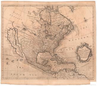


Ithamar P. Berthrong
1908
E.B. & E.C. Kellogg
1846